Yukikura-dake – Asahi-dake Route
Mt. Shioruma-dake ~ Mt. Yukikura-dake ~ Kitamata-koya Mountain Hut ~ Ogawa Onsen Motoyu Hot Spring
Technical level:C
Physical strength:8
Difficulty ★★★★
Descend the ridgeline from Mt. Shirouma-dake
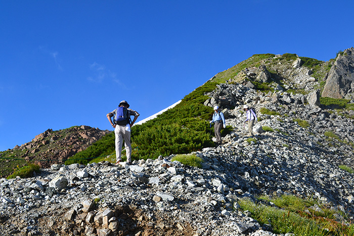
On this route, the view of the north part of the North Japan Alps and alpine plants can be enjoyed. Because only a few hikers choose this route, it will not get busy even during the busiest hiking season. It is a great feeling to get to enjoy the view of the northern mountains of the North Japan Alps all by yourself!
Access to Sarukura
Access to Ogawa Onsen
●Hiking Data
Schedule: Two nights and three days
(Three days and four nights if you count from Ogawa Onsen hot spring (From Sarukura)
Walking hours: 21 hours 25 minutes
Walking distance: 34.171 km
Variance in elevation: 3,133 m
Mt. Shirouma-dake

Elevation 2,932m
↓ 2 hours 50 minutes
Mt. Yukikura-dake
Elevation 2,610m
↓ 3 hours 30 minutes
Mt. Asahi-dake

Elevation 2,417m
↓ 40 minutes
Asahi-koya Mountain Hut
Elevation 2,140m
↓ 4 hours 30 minutes
Kitamata-koya Mountain Hut
Elevation 690m
↓ 3 hours
Ogawa Onsen Motoyu Hot Spring
Elevation 250m
Route Guide
For the route to Mt. Shirouma-dake, please refer to 1. Mt. Shirouma-dake.
Two nights and three days are scheduled for this route. It is recommended that you stay at Asahi-koya mountain hut the first night and Ogawa Onsen Motoyu hot spring the second night. The hiking hours scheduled for the first day are 7 hours and 7 hours 30 minutes the second day.
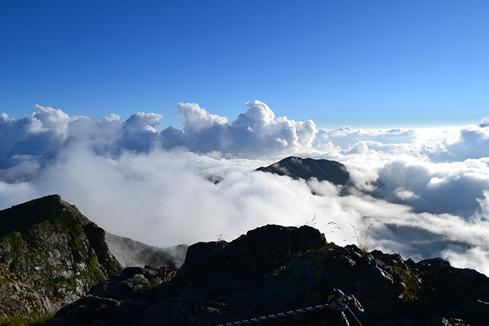
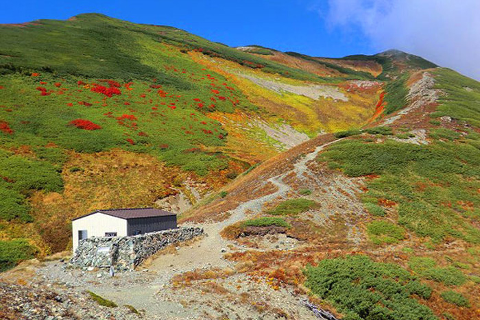
From the summit of Mt. Shirouma-dake, descend towards Hakuba-O-ike area. Enter a wide ridgeline on the left at Mikuni-sakai. A dynamic view of Mt. Yukikura-dake and Mt. Asahi-dake spreads out in front of you. Naga-ike, a pond by the edge of a snowy valley, can be seen at the lower left. Just before you the saddle of Mt. Hari-gatake, proceed as you pass a mining road to Renge Onsen hot spring on the right. Beds of Gypsy Roses should welcome you. From the saddle, enter the trail on the lower right, which passes around the middle of the mountains on the east side of Mt. Hari-gatake. Descend for a while, then proceed on the trail as it runs horizontally. Along the way, you will cross a valley covered in snow remaining even in late summer. When the snow finally melts, alpine plants will bloom and form flower fields, one after another. Descend on the gravel trail with a gradual slope. Yukikura-dake emergency shelter will be reached shortly. This shelter plays an important role on this long route. If you plan on using the shelter, you do so respectfully.
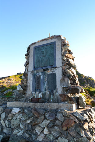
An uphill to Mt. Yukikura-dake should not be too hard. The trail ascends in a small zigzag pattern. When the slope becomes gradual, the summit of Mt. Yukikura-dake will be reached. A stone monument of the name of the mountain is present. Long ago, Mt. Shirouma-dake was called Mt. Dai-renge-dake. You might find an explanation for this by taking in the great view spreading out behind you. In front, Mt. Asahi-dake and the triangular roof of Asahi-koya mountain hut, where you will spend the night, can be seen.
From Mt. Yukikura-dake, descend the gradual slope on the Toyama side, which crosses the ridgeline occasionally. Go off the ridgeline and take the trail to the right. Yukikura-ike can be seen on the lower right. Pass the rocky zone and continue to the left. Descend as you cross the ridgeline. When you repeat a zigzag pattern a few times, the trail returns to the ridgeline. When you descend a wide and gradual graveled slope off the ridgeline, Bame-daira will be reached. In your direction, Mt. Akaotoko-yama can be seen. Walk through the forest of Abies Veitchii and Pinus Pumila, and then the trail comes right beneath Tsubame-iwa. The trail traverses towards Mt. Asahi-dake. When it passes some ups and downs, it comes to the edge of Kozakura-gahara. It is a swamp with a long and narrow shape. There is a promenade set up so follow it. Hakusan-kozakura or Avens will spread out at your feet. Pass by the side of the swamp. When the trail becomes an ascending slope, Kozakura-gahara will be passed.
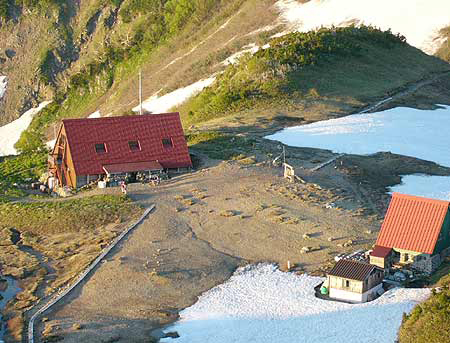
The junction where the meeting of the trails to Mt. Asahi-dake and Suihei-dou extending to the middle of the mountain will be reached shortly. Go straight at the junction to the summit of Mt. Asahi-dake. Ascend through the forest zone. Climb at a steady pace at the steep slope. When the slope becomes gradual, the summit of Mt. Asahi-dake will be reached. It is a wide grass field-like summit. Check your view with the observatory panel. Descend on the ridgeline to the west. The trail goes through a low-height forest of Abies Veitchii and Pinus Pumila. It descends in a zigzag pattern. The trail merges into Suihei-do at Mizutani-no-koru. Asahi-koya mountain hut, where you will stay for the night, locates just ahead of the junction. There are plenty of alpine flowers in bloom around the camping site and it is like a treasure house. If you are not confident in your physical strength, follow Suihei-do to Asahi-koya mountain hut, then take a round trip to Mt. Asahi-dake the next morning.
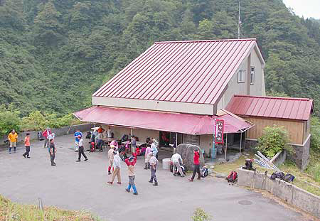
You are scheduled to hike for 7 hours 30 minutes on the second day. It will mostly be a descent so you have to control your hiking pace to avoid falling. Have a good rest at Asahi-koya mountain hut. From the hut, descend on the gradual-slope ridgeline. If snow still remains, you have to be careful not to slip. The trail comes to a wide grass field. That would be Yuhi-gahara. Avens will be beautifully in bloom. When it was found in the Taisho-era, it was called a “Paradise in heaven”. As the name of Yuhi-gahara says, the sunset (Yuhi) at the field is beautiful. Descend on the steep slope with the use of chains and ascend back through the forest. Then you will reach Mt. Iburi-yama. From this point, the slope becomes very steep. It starts out gradually but shortly the trail enters into a forest zone without a view and the slope becomes a steep downhill. Beeches can be spotted around Hachigou-me. Buna-daira, a small plateau, is located at Gogou-me. Take a short break. From here, the trail continues as a steep downhill. Descend while you check the distance indicators along the trail. Kitamata-koya mountain hut is located where you cross a hanging bridge beneath the Kitamata dam.
You will walk on the roadway from the hut to Ogawa Onsen hot spring. It takes about 3 hours, however, if you are too exhausted, you may call a taxi. It will be easy if you call a taxi from Asahi-koya mountain hut and tell them your estimated arrival time at Kitamata-koya mountain hut. If you are a strong hiker, you can call a taxi to Ogawa Onsen hot spring, then ride to Tomari Station of the Toyama railway.