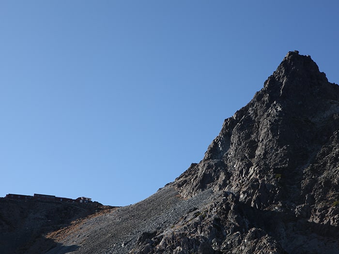
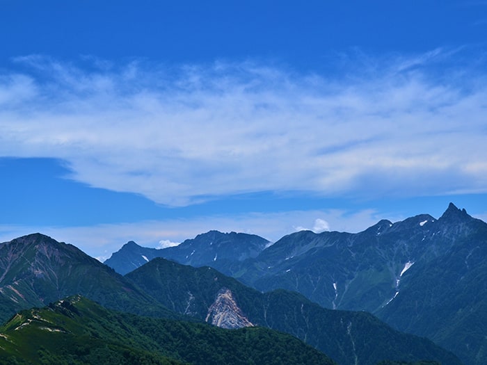
Yari-gatake, the Japanese name for this mountain was thus named because it looked like the head of a spear.
Yari means spear in Japanese. In 1828 the monk BANRYU was the first to climb Mt. Yari-gatake; WALTER WESTON who is known as the father of modern Japanese mountain climbing, ascended it in 1892. It is referred to as the Japanese Matter Horn as it is a sharp rock peak; it is the land mark of the Northern Alps, and is centered in the southern mountain area of the Northern Alps.
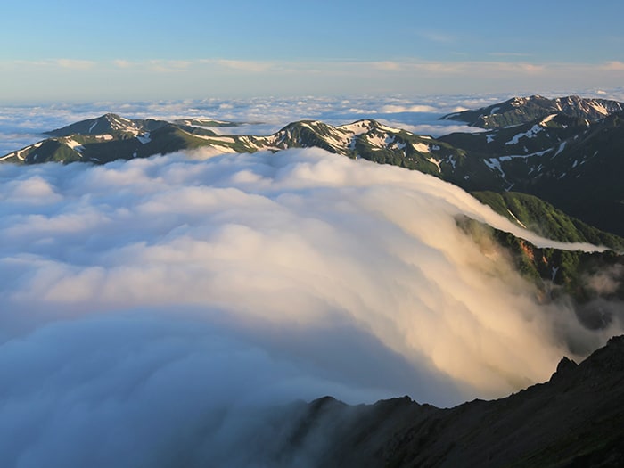
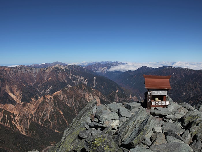
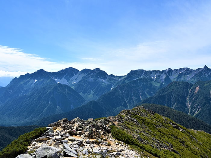
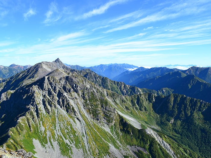
When you stand up on this narrow peak, you will have an amazing panoramic view of the entire Northern Alps.
Most mountain climbers would like to stand on the peak of this mountain at least one time.
The elevation is 3180m, making it the fifth highest elevation in Japan.
The 100 famous mountains of Japan. The 100 famous flowering mountains of Japan.
Mt. Yari-gadake Elevation: 3,180m
The mountain which is most loved in Japanese climber.
The attraction is the irresistible landscape.
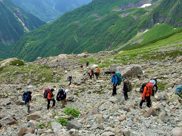
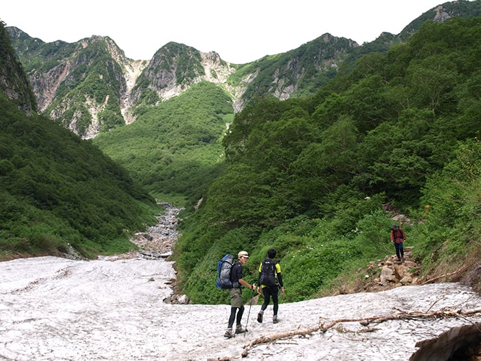
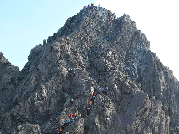
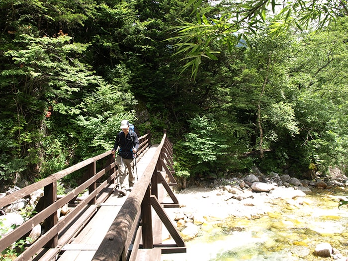
There are many routes to ascend Mt.Yari-gatake,from intermediate to advanced level which includes rocky terrain; any of these routes provide the opportunity to enjoy the magnificent scenery of the Northern Alps.
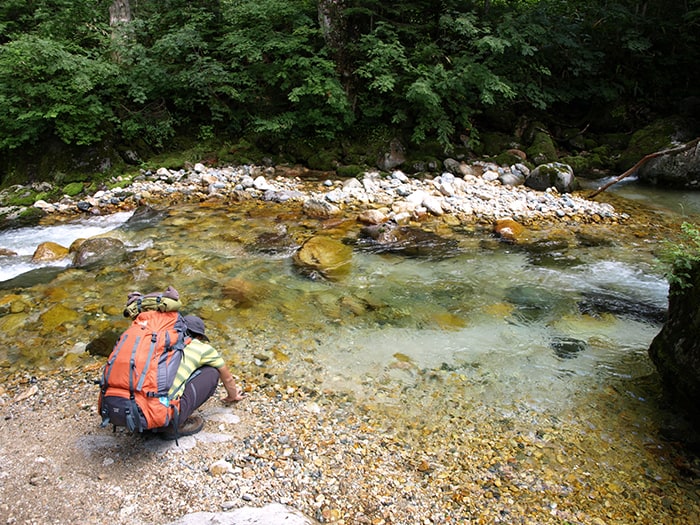
For starters on a route, the spear head can be seen reflected in the water of a mysterious pond; in the early summer, beautiful flowers abound, in the fall autumnal coloring… depending on the season or route the mountain face changes dramatically.
When you ascend the ladder an additional 100m from the hut immediately below the peak, finally you can stand on the top of Mt.Yari-gadake, an elevation of 3180m.
You will be deeply satisfied with a panoramic view of the entire Northern Alps, the Central alps, the Southern Alps,and if you are lucky you might even see Mt. Fuji-san.
※During May and June in Japan’s mountains, snow remains on the ground and crampons and pickerels will continue to be needed during this period.
※Japan’s mountains will be closed October through April due to the snow.
Trailhead vicinity weather
Weekly weather forecast zone:Gifu Prefecture Hida
| DAY | WEATHER | LOWEST | HIGHEST |
|---|---|---|---|
| 7/20 | 26℃ | 34℃ | |
| 7/21 | 27℃ | 35℃ | |
| 7/22 | 27℃ | 35℃ | |
| 7/23 | 26℃ | 36℃ | |
| 7/24 | 26℃ | 36℃ | |
| 7/25 | 25℃ | 36℃ |
This is a publication of the calculated figures for weather predictions and is not the weather forecast. There are instances where there will be big differences in the values stated for the mountains, in accord with the topography as well as sunlight, etc. so please take care.
72 hours weather information:Kamikochi Kappa Bridge, Azumi, Matsumoto City, Nagano Prefecture
| Date and time |
7/19 9:00 |
7/19 10:00 |
7/19 11:00 |
7/19 12:00 |
7/19 13:00 |
7/19 14:00 |
7/19 15:00 |
7/19 16:00 |
7/19 17:00 |
7/19 18:00 |
7/19 19:00 |
7/19 20:00 |
7/19 21:00 |
7/19 22:00 |
7/19 23:00 |
7/20 0:00 |
7/20 1:00 |
7/20 2:00 |
7/20 3:00 |
7/20 4:00 |
7/20 5:00 |
7/20 6:00 |
7/20 7:00 |
7/20 8:00 |
7/20 9:00 |
7/20 10:00 |
7/20 11:00 |
7/20 12:00 |
7/20 13:00 |
7/20 14:00 |
7/20 15:00 |
7/20 16:00 |
7/20 17:00 |
7/20 18:00 |
7/20 19:00 |
7/20 20:00 |
7/20 21:00 |
7/20 22:00 |
7/20 23:00 |
7/21 0:00 |
7/21 1:00 |
7/21 2:00 |
7/21 3:00 |
7/21 4:00 |
7/21 5:00 |
7/21 6:00 |
7/21 7:00 |
7/21 8:00 |
7/21 9:00 |
7/21 10:00 |
7/21 11:00 |
7/21 12:00 |
7/21 13:00 |
7/21 14:00 |
7/21 15:00 |
7/21 16:00 |
7/21 17:00 |
7/21 18:00 |
7/21 19:00 |
7/21 20:00 |
7/21 21:00 |
7/21 22:00 |
7/21 23:00 |
7/22 0:00 |
|---|---|---|---|---|---|---|---|---|---|---|---|---|---|---|---|---|---|---|---|---|---|---|---|---|---|---|---|---|---|---|---|---|---|---|---|---|---|---|---|---|---|---|---|---|---|---|---|---|---|---|---|---|---|---|---|---|---|---|---|---|---|---|---|---|
| Weather | ||||||||||||||||||||||||||||||||||||||||||||||||||||||||||||||||
| Temperature | 17℃ | 19℃ | 20℃ | 20℃ | 20℃ | 20℃ | 20℃ | 19℃ | 19℃ | 18℃ | 17℃ | 16℃ | 16℃ | 15℃ | 15℃ | 15℃ | 14℃ | 14℃ | 13℃ | 13℃ | 13℃ | 13℃ | 14℃ | 16℃ | 18℃ | 19℃ | 20℃ | 21℃ | 21℃ | 21℃ | 21℃ | 21℃ | 20℃ | 19℃ | 19℃ | 17℃ | 17℃ | 16℃ | 16℃ | 15℃ | 15℃ | 15℃ | 14℃ | 14℃ | 14℃ | 14℃ | 15℃ | 17℃ | 19℃ | 20℃ | 20℃ | 20℃ | 20℃ | 19℃ | 19℃ | 19℃ | 18℃ | 18℃ | 18℃ | 17℃ | 17℃ | 17℃ | 16℃ | 16℃ |
| Precipitation | 0mm/h | 0mm/h | 0mm/h | 0mm/h | 0mm/h | 0mm/h | 0mm/h | 0mm/h | 0mm/h | 0mm/h | 0mm/h | 0mm/h | 0mm/h | 0mm/h | 0mm/h | ※ 16時間以降は表示されません | ||||||||||||||||||||||||||||||||||||||||||||||||
| Wind direction |
northeast 1m/s |
northeast 1m/s |
northeast 1m/s |
northeast 2m/s |
northeast 2m/s |
northeast 2m/s |
northeast 2m/s |
northeast 2m/s |
northeast 2m/s |
northeast 1m/s |
northeast 1m/s |
northeast 1m/s |
northeast 1m/s |
northeast 1m/s |
northeast 1m/s |
northeast 1m/s |
northeast 1m/s |
northeast 1m/s |
northeast 1m/s |
northeast 1m/s |
northeast 1m/s |
northeast 1m/s |
northeast 1m/s |
0m/s |
northeast 1m/s |
northeast 1m/s |
northeast 1m/s |
northeast 2m/s |
northeast 2m/s |
northeast 2m/s |
northeast 2m/s |
northeast 1m/s |
northeast 1m/s |
northeast 1m/s |
northeast 1m/s |
northeast 1m/s |
northeast 1m/s |
northeast 1m/s |
northeast 1m/s |
northeast 1m/s |
northeast 1m/s |
northeast 1m/s |
northeast 1m/s |
northeast 1m/s |
northeast 1m/s |
northeast 1m/s |
northeast 1m/s |
northeast 1m/s |
0m/s |
northeast 1m/s |
northeast 1m/s |
northeast 1m/s |
northeast 1m/s |
northeast 1m/s |
northeast 1m/s |
northeast 1m/s |
northeast 1m/s |
northeast 1m/s |
northeast 1m/s |
0m/s |
northeast 1m/s |
northeast 1m/s |
northeast 1m/s |
northeast 1m/s |
※The weather information will be information on 5km square including the relevant point.
※天気予報マークは一次細分区域から表示しています
View of Mt. Yari-gadake

Route Information
A-Basic course sorted by trailheads
From Kamikochi
From Shin-hotaka Onsen hot springs
B‐Variation courses from Mt. Yari-gatake sorted by experience and physical strength
-
Nishi-kama o’ne Route
③ Shin-hotaka Onsen ~ Koike-shindou Trailhead ~ Yumiori Junction ~ Sugoroku-goya Mountain hut ~ Mt. Sugoroku-dake ~ Senjyo-nokkoshi ~ Mt. Yari-gatake ~ Yokoo ~ Kamikouchi (Difficulty level: ⛰️⛰️⛰️⛰️) -
Omote Ginza Panorama Route
④ Nakabusa Onsen hot spring ~ Mt. Tsubakuro-dake ~ O-tensho Mountain hut ~ Mt. Nishi-dake ~ Minamata-nokkoshi ~ O-yari Mountain hut ~ Mt. Yari-gatake ~ Yokoo ~ Kamikochi (Difficulty level: ⛰️⛰️⛰️⛰️) -
Ura Ginza Panorama Route
⑤ Takase dam ~ Eboshi-koya Mountain hut ~ Masago junction ~ Mt. Suisho-dake ~ Mt. Washiba-dake ~ Mt. Sugorku-dake ~ Senjo-nokkoshi ~ Mt. Yari-gatake ~ Yoko ~ Kamikochi (expert)(Difficulty level: ⛰️⛰️⛰️⛰️⛰️)
