
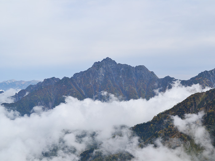
In the year 1907 (Meiji 40), the Army land survey section reached the summit with great difficulty. The story of their setting of the triangulation point was novelized and a movie was released, which made this mountain popular even among non-mountain lovers. This mountain is called “a palace of rocks and ice” due to the pyramidal shape of the mountain formed by steep rock cliffs and glaciers.
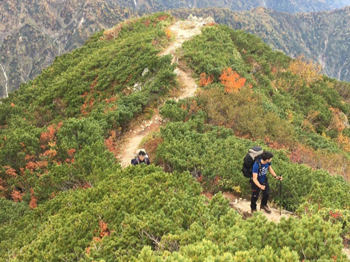
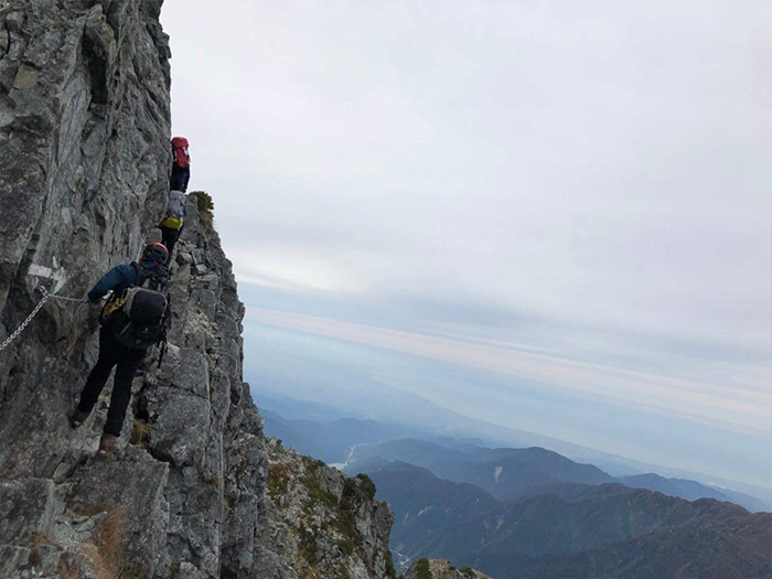
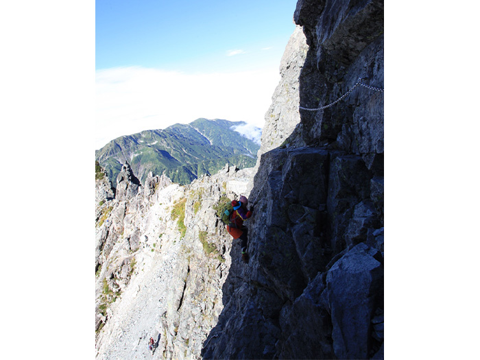
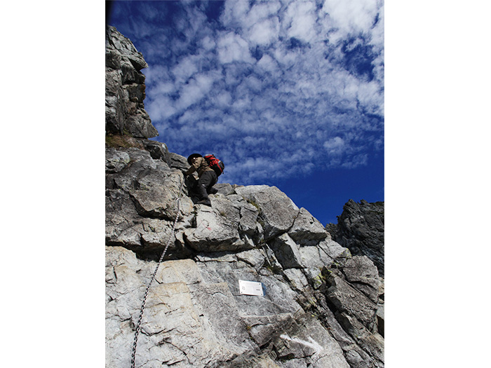
The solemn stance of the mountain might even keep hikers away from the summit. In fact, it is a difficult approach from Chojirou Valley or Heizou Valley without advanced experience and skills, however, the approaches from Hayatsuki o’ne or Bessan o’ne are reachable even by beginners. Even though these ridgelines are accessible to beginners, these paths include many hazardous spots involving the use of ladders and chains, so caution is necessary through the entire approach. These paths are ranked as the most difficult among the Japanese Alps yet some of the most popular trails that [Gakujin]-mountain lovers, long for in Japan.
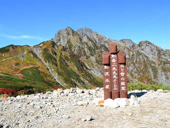
Mt. Tsurugi-dake Elevation: 2,999m
Two approaches, one from Hayatsuki o’ne and another from Bessan o’ne are relatively accessible for beginners, however, the path from Hayatsuki o’ne is the main route in winter. The elevation of the difference is 2,200m and this would be challenging hiking for beginners. That makes the Bessan o’ne the best choice for beginners in summer.
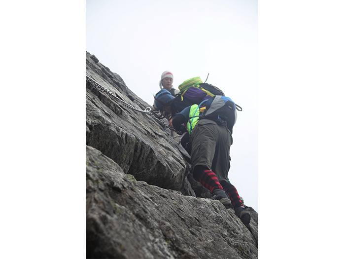
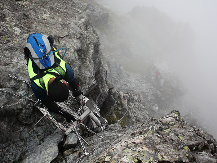
This path includes the famous [Kani no Tatebai – Vertical crawl of crabs] and [Kani no Yokobai – Horizontal crawl of crabs]. Kani no Tatebai is not too difficult to pass with appropriate experience in the use of chains. For Kani no Yokobai, caution needs to be employed especially when beginning with the chains. Helmet use is necessary. Trekking poles are useless after the Ippuku-tsurugi so make sure to pack them away in your backpack.
Trailhead vicinity weather
Weekly weather forecast zone:Eastern Toyama Prefecture
| DAY | WEATHER | LOWEST | HIGHEST |
|---|---|---|---|
| 7/14 | 24℃ | 34℃ | |
| 7/15 | 25℃ | 33℃ | |
| 7/16 | 26℃ | 35℃ | |
| 7/17 | 26℃ | 35℃ | |
| 7/18 | 25℃ | 36℃ | |
| 7/19 | 25℃ | 35℃ |
This is a publication of the calculated figures for weather predictions and is not the weather forecast. There are instances where there will be big differences in the values stated for the mountains, in accord with the topography as well as sunlight, etc. so please take care.
72 hours weather information:Ashikuraji Tateyama Murodou-daira, Tateyama-cho, Nakashinagawa-gun, Toyama
| Date and time |
7/13 17:00 |
7/13 18:00 |
7/13 19:00 |
7/13 20:00 |
7/13 21:00 |
7/13 22:00 |
7/13 23:00 |
7/14 0:00 |
7/14 1:00 |
7/14 2:00 |
7/14 3:00 |
7/14 4:00 |
7/14 5:00 |
7/14 6:00 |
7/14 7:00 |
7/14 8:00 |
7/14 9:00 |
7/14 10:00 |
7/14 11:00 |
7/14 12:00 |
7/14 13:00 |
7/14 14:00 |
7/14 15:00 |
7/14 16:00 |
7/14 17:00 |
7/14 18:00 |
7/14 19:00 |
7/14 20:00 |
7/14 21:00 |
7/14 22:00 |
7/14 23:00 |
7/15 0:00 |
7/15 1:00 |
7/15 2:00 |
7/15 3:00 |
7/15 4:00 |
7/15 5:00 |
7/15 6:00 |
7/15 7:00 |
7/15 8:00 |
7/15 9:00 |
7/15 10:00 |
7/15 11:00 |
7/15 12:00 |
7/15 13:00 |
7/15 14:00 |
7/15 15:00 |
7/15 16:00 |
7/15 17:00 |
7/15 18:00 |
7/15 19:00 |
7/15 20:00 |
7/15 21:00 |
7/15 22:00 |
7/15 23:00 |
7/16 0:00 |
|---|---|---|---|---|---|---|---|---|---|---|---|---|---|---|---|---|---|---|---|---|---|---|---|---|---|---|---|---|---|---|---|---|---|---|---|---|---|---|---|---|---|---|---|---|---|---|---|---|---|---|---|---|---|---|---|---|
| Weather | ||||||||||||||||||||||||||||||||||||||||||||||||||||||||
| Temperature | 20℃ | 20℃ | 19℃ | 17℃ | 16℃ | 16℃ | 15℃ | 15℃ | 15℃ | 15℃ | 15℃ | 15℃ | 14℃ | 14℃ | 14℃ | 16℃ | 17℃ | 18℃ | 19℃ | 19℃ | 20℃ | 21℃ | 21℃ | 20℃ | 18℃ | 18℃ | 18℃ | 17℃ | 16℃ | 17℃ | 16℃ | 16℃ | 16℃ | 16℃ | 16℃ | 16℃ | 16℃ | 16℃ | 16℃ | 16℃ | 18℃ | 19℃ | 20℃ | 20℃ | 20℃ | 19℃ | 20℃ | 21℃ | 21℃ | 19℃ | 18℃ | 16℃ | 16℃ | 16℃ | 16℃ | 16℃ |
| Precipitation | 0mm/h | 0mm/h | 0mm/h | 0mm/h | 0mm/h | 0mm/h | 0.4mm/h | 0mm/h | 0mm/h | 0mm/h | 0mm/h | 0mm/h | 0mm/h | 0mm/h | 0mm/h | ※ 16時間以降は表示されません | ||||||||||||||||||||||||||||||||||||||||
| Wind direction |
0m/s |
south 1m/s |
south 1m/s |
south 1m/s |
south 1m/s |
south 1m/s |
south 1m/s |
south 1m/s |
south 2m/s |
south 2m/s |
south 2m/s |
south 2m/s |
south 3m/s |
south 3m/s |
south 3m/s |
south 3m/s |
south 4m/s |
south 4m/s |
south 3m/s |
south 3m/s |
south 2m/s |
south 2m/s |
south 1m/s |
south 1m/s |
south 1m/s |
south 1m/s |
south 1m/s |
south 2m/s |
south 2m/s |
south 2m/s |
south 3m/s |
south 3m/s |
south 3m/s |
south 3m/s |
south 3m/s |
south 3m/s |
south 2m/s |
south 2m/s |
south 2m/s |
south 2m/s |
south 3m/s |
south 3m/s |
south 2m/s |
south 2m/s |
south 1m/s |
south 1m/s |
south 1m/s |
south 1m/s |
south 1m/s |
south 1m/s |
south 1m/s |
south 1m/s |
south 2m/s |
south 2m/s |
south 3m/s |
south 3m/s |
※The weather information will be information on 5km square including the relevant point.
※天気予報マークは一次細分区域から表示しています
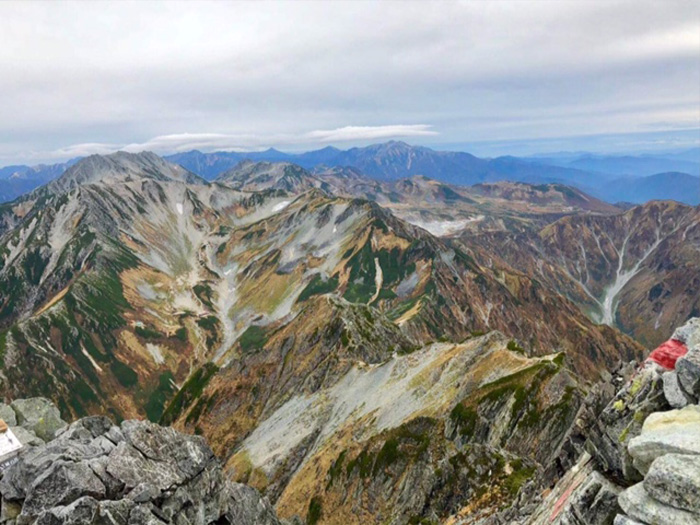
View of Mt. Tsurugi-dake
Route Information
A-Basic course sorted by trailheads
From Murodo Trailhead
From Banbajima
A-Basic course sorted by trailheads
From Murodo Trailhead
-
Tsurugi - sawa Route
③Murodo ~ Bessan-nokkoshi ~ Chojiro-deai ~ Sennin Toge Pass ~ Ikenodaira-koya Mountain Hut ~ Sennin Toge Pass ~ Kuranosuke-taira ~ Kurobe Dam (Difficulty level: ⛰️⛰️⛰️⛰️) -
Tsurugi-sawa - Suihei-hodo
④Murodo ~ Bessan-nokkoshi ~ Tsurugi-zawa-koya Mountain Hut ~ Chojiro-valley-deai ~ Masago-zawa Lodge ~ Sennin-ike hut ~ Asohara Onsen-koya Mountain Hut ~ Keyaki-daira(Difficulty level: ⛰️⛰️⛰️⛰️)
