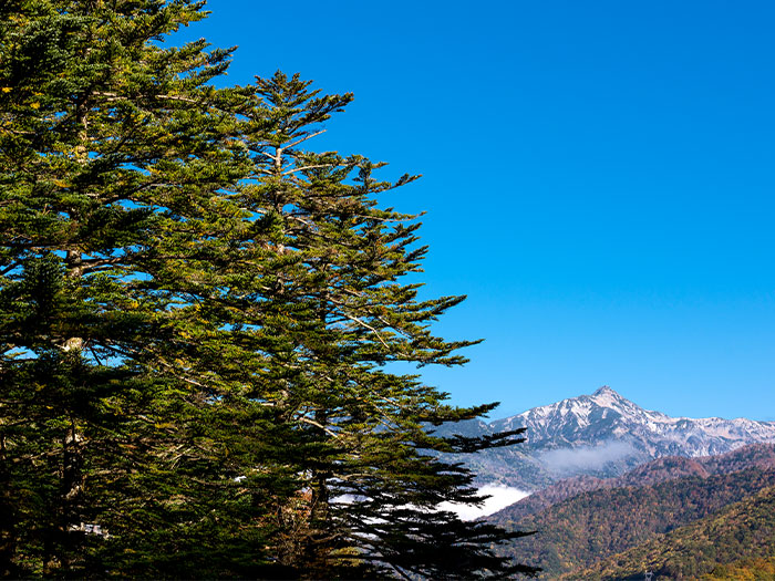
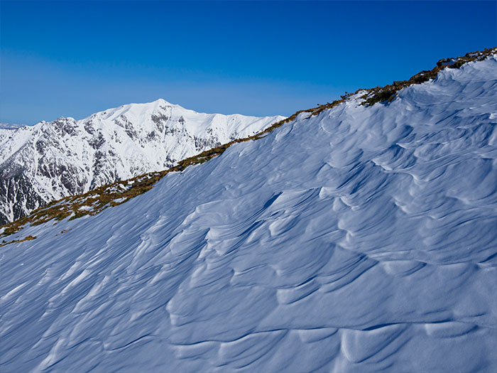
This mountain is located in the north of Gifu prefecture at an elevation of 2,897 m. It is the highest mountain in the prefecture. The east slope is collapsed and covered by quartz. Metal minerals used to be extracted from the wall. The summit of the mountain is in the beautiful shape of a hat when seen from any direction. In accordance with mountain worship in the Edo era, Enku and Banryu climbed the mountain. At that time, the mountain was also called Mt. Kata-dake or Mt. Kataga-take. The history of modern mountain climbing appears to date to the year 1894 when Weston reached the mountain. The view of Mt. Yari-gatake and the Hotaka Mountains are powerfully beautiful, however, not many hikers approach this mountain.
Mt. Kasa-gatake: Elevation 2,987 m
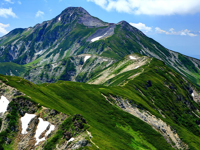
From the summit of Mt. Yari-gatake, a shining whitish mountain can be seen straight ahead. That is Mt. Kasa-gatake. Some may be stunned by its huge shape and the beauty of this mountain. The shape of the mountain is so powerful that it may trigger one’s willingness to climb the mountain. However, the route is long and steep and many hesitate to challenge the mountain. Due to the toughness of this route, there are not may hikers even during the busiest season. On the other hand, there are some hikers who repeatedly visit this mountain because they get addicted to it once they know of its beauty. Some enjoy hiking Mt. Kasa-gatake more than Mt. Yari-gatake or the Hotaka mountains. Few hike from one mountain to another, starting from the direction of Mt. Washiba-dake, then proceeding towards Sugoroku-koya Mountain hut. Many hike to Mt. Yariga-take via Nishikama o’ne.
There are two classic approaches to Mt. Kasa-gatake. One starts from Shinhotaka hot springs and proceeds to Kasa-shindo. Another starts from Shinhotaka hot springs and proceeds to Koike-shindo and to Mt. Kasa-gatake via Yumiori junction. The second route avoids the steep uphill on Kasa-shindo and some hikers proceed to Mt. Sugoroku-dake. Two courses are introduced here.
Trailhead vicinity weather
Weekly weather forecast zone:Gifu Prefecture Hida
| DAY | WEATHER | LOWEST | HIGHEST |
|---|---|---|---|
| 7/13 | 26℃ | 34℃ | |
| 7/14 | 25℃ | 31℃ | |
| 7/15 | 25℃ | 31℃ | |
| 7/16 | 26℃ | 31℃ | |
| 7/17 | 25℃ | 30℃ | |
| 7/18 | 26℃ | 31℃ |
This is a publication of the calculated figures for weather predictions and is not the weather forecast. There are instances where there will be big differences in the values stated for the mountains, in accord with the topography as well as sunlight, etc. so please take care.
72 hours weather information:Kamisaka, Okuhida Onsenkyo, Takayama City, Gifu Prefecture
| Date and time |
7/12 16:00 |
7/12 17:00 |
7/12 18:00 |
7/12 19:00 |
7/12 20:00 |
7/12 21:00 |
7/12 22:00 |
7/12 23:00 |
7/13 0:00 |
7/13 1:00 |
7/13 2:00 |
7/13 3:00 |
7/13 4:00 |
7/13 5:00 |
7/13 6:00 |
7/13 7:00 |
7/13 8:00 |
7/13 9:00 |
7/13 10:00 |
7/13 11:00 |
7/13 12:00 |
7/13 13:00 |
7/13 14:00 |
7/13 15:00 |
7/13 16:00 |
7/13 17:00 |
7/13 18:00 |
7/13 19:00 |
7/13 20:00 |
7/13 21:00 |
7/13 22:00 |
7/13 23:00 |
7/14 0:00 |
7/14 1:00 |
7/14 2:00 |
7/14 3:00 |
7/14 4:00 |
7/14 5:00 |
7/14 6:00 |
7/14 7:00 |
7/14 8:00 |
7/14 9:00 |
7/14 10:00 |
7/14 11:00 |
7/14 12:00 |
7/14 13:00 |
7/14 14:00 |
7/14 15:00 |
7/14 16:00 |
7/14 17:00 |
7/14 18:00 |
7/14 19:00 |
7/14 20:00 |
7/14 21:00 |
7/14 22:00 |
7/14 23:00 |
7/15 0:00 |
|---|---|---|---|---|---|---|---|---|---|---|---|---|---|---|---|---|---|---|---|---|---|---|---|---|---|---|---|---|---|---|---|---|---|---|---|---|---|---|---|---|---|---|---|---|---|---|---|---|---|---|---|---|---|---|---|---|---|
| Weather | |||||||||||||||||||||||||||||||||||||||||||||||||||||||||
| Temperature | 20℃ | 20℃ | 19℃ | 18℃ | 17℃ | 17℃ | 16℃ | 16℃ | 15℃ | 14℃ | 14℃ | 14℃ | 14℃ | 14℃ | 13℃ | 14℃ | 15℃ | 15℃ | 16℃ | 18℃ | 19℃ | 20℃ | 21℃ | 21℃ | 21℃ | 21℃ | 20℃ | 18℃ | 17℃ | 16℃ | 16℃ | 16℃ | 15℃ | 15℃ | 15℃ | 15℃ | 16℃ | 16℃ | 15℃ | 16℃ | 17℃ | 18℃ | 19℃ | 19℃ | 20℃ | 20℃ | 20℃ | 19℃ | 20℃ | 19℃ | 18℃ | 17℃ | 16℃ | 16℃ | 16℃ | 15℃ | 15℃ |
| Precipitation | 0mm/h | 0mm/h | 0mm/h | 0mm/h | 0mm/h | 0mm/h | 0mm/h | 0mm/h | 0mm/h | 0mm/h | 0mm/h | 0mm/h | 0mm/h | 0mm/h | 0mm/h | ※ 16時間以降は表示されません | |||||||||||||||||||||||||||||||||||||||||
| Wind direction |
east-northeast 2m/s |
east-northeast 2m/s |
east-northeast 2m/s |
east-northeast 1m/s |
east-northeast 1m/s |
east-northeast 3m/s |
east-northeast 2m/s |
east-northeast 2m/s |
east-northeast 2m/s |
east-northeast 2m/s |
east-northeast 1m/s |
east-northeast 1m/s |
east-northeast 1m/s |
east-northeast 1m/s |
east-northeast 1m/s |
east-northeast 1m/s |
east-northeast 1m/s |
east-northeast 2m/s |
east-northeast 1m/s |
east-northeast 1m/s |
east-northeast 1m/s |
east-northeast 2m/s |
east-northeast 2m/s |
east-northeast 2m/s |
east-northeast 2m/s |
east-northeast 2m/s |
east-northeast 2m/s |
east-northeast 1m/s |
east-northeast 2m/s |
east-northeast 1m/s |
east-northeast 1m/s |
east-northeast 1m/s |
east-northeast 1m/s |
east-northeast 1m/s |
east-northeast 2m/s |
east-northeast 2m/s |
east-northeast 3m/s |
east-northeast 3m/s |
east-northeast 2m/s |
east-northeast 2m/s |
east-northeast 2m/s |
east-northeast 2m/s |
east-northeast 2m/s |
east-northeast 2m/s |
east-northeast 2m/s |
east-northeast 1m/s |
east-northeast 1m/s |
0m/s |
east-northeast 1m/s |
east-northeast 2m/s |
east-northeast 2m/s |
east-northeast 2m/s |
east-northeast 2m/s |
east-northeast 1m/s |
0m/s |
east-northeast 1m/s |
east-northeast 1m/s |
※The weather information will be information on 5km square including the relevant point.
※天気予報マークは一次細分区域から表示しています
View of Mt. Kasa-gatake