The long (38km) trail from the NAGATO cattle farm in NAGAWA city/NAGANO prefecture to the two peaks KIRIGAMINE and UTSUKUSHIGAHARA of the famous 100 mountains is known as the Central Divide Trail.
The BUNSUIREI refers to the continuous line dividing the river system between the Japan Sea and the Ocean.
Most of the water on the north side of this divide goes to the Japan sea and the water on the south side of this divide drains into the ocean.
This trail is one of the 16 long trail courses in Japan that have been recognized by the JAPAN TRAIL ASSOCIATION, and is the representative plateau hiking course that connects the highlands.
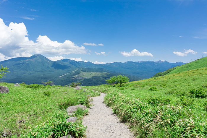
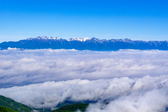
In addition to delightful walking in the clear air and gentle breeze on this course, it is a genuine panorama hiking course where one may see the Yatsugatake mountain range and the southern, central and northern alps.
Snow hiking: January-March
Planning :1 night or 2 nights to cover the course
On this trail course, the difference in elevation between high point and low is only 686 m over the span of 38 km. Importantly, hikers can enjoy pleasant walking on this relatively flat course on their way to climb the peaks of over 1500 m.
There are 5 different courses.
You can choose to walk through all of them at once or choose the courses you are interested in and walk through them at leisure.
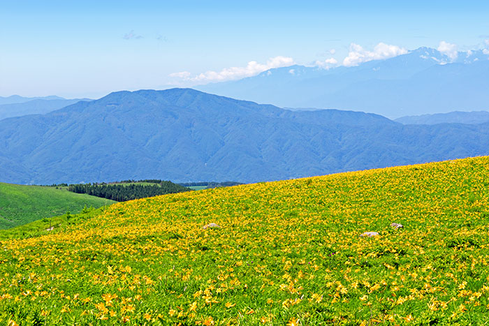
After setting forth from the NAGATO cattle farm, while viewing the gentle form of TATESHINAYAMA, you will walk through deep forest, and ascend to KURUMAYAMA from SHIRAKABAKO, while taking in the 360 degree view of the grassfields.
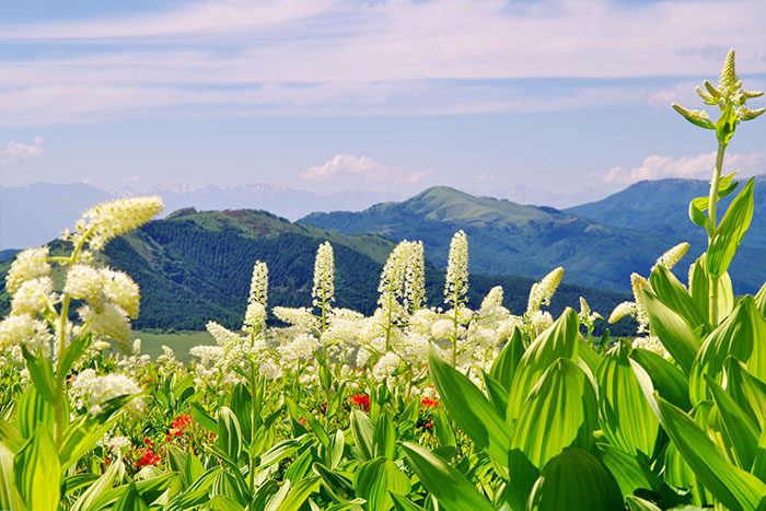
You will be welcomed by a sea of NIKKOKISUGE, a type of lily if you visit in JULY. On your way you will pass through the NAKASENDO which is an old and classic road in Japan, as you make your way to UTSUKUSHIGAHARA via MITSUMINESAN and CHAUSUYAMA.
The real pleasure of plateau trekking is not only the refreshment
of walking through the deep and rich forest but also the refreshment
from the views of the magnificent landscape.
There is really no other trekking course
from which you may enjoy fabulous views
of all the alps including YATSUGADAKE,
The Southern Alps, The Central Alps and The Northern
Alps.
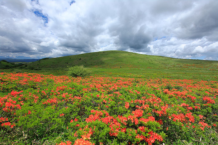
During each month from spring to fall, alpine flowers blossom
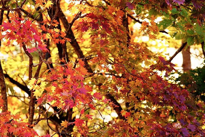
along the course and one may enjoy the color changes of the leaves
and the grasses in late fall.
The snowshoe-hiking tour is a favorite during the winter.
Trailhead vicinity weather
| DAY | WEATHER | LOWEST | HIGHEST |
|---|---|---|---|
This is a publication of the calculated figures for weather predictions and is not the weather forecast. There are instances where there will be big differences in the values stated for the mountains, in accord with the topography as well as sunlight, etc. so please take care.
| Date and time |
7/19 8:00 |
7/19 9:00 |
7/19 10:00 |
7/19 11:00 |
7/19 12:00 |
7/19 13:00 |
7/19 14:00 |
7/19 15:00 |
7/19 16:00 |
7/19 17:00 |
7/19 18:00 |
7/19 19:00 |
7/19 20:00 |
7/19 21:00 |
7/19 22:00 |
7/19 23:00 |
7/20 0:00 |
7/20 1:00 |
7/20 2:00 |
7/20 3:00 |
7/20 4:00 |
7/20 5:00 |
7/20 6:00 |
7/20 7:00 |
7/20 8:00 |
7/20 9:00 |
7/20 10:00 |
7/20 11:00 |
7/20 12:00 |
7/20 13:00 |
7/20 14:00 |
7/20 15:00 |
7/20 16:00 |
7/20 17:00 |
7/20 18:00 |
7/20 19:00 |
7/20 20:00 |
7/20 21:00 |
7/20 22:00 |
7/20 23:00 |
7/21 0:00 |
7/21 1:00 |
7/21 2:00 |
7/21 3:00 |
7/21 4:00 |
7/21 5:00 |
7/21 6:00 |
7/21 7:00 |
7/21 8:00 |
7/21 9:00 |
7/21 10:00 |
7/21 11:00 |
7/21 12:00 |
7/21 13:00 |
7/21 14:00 |
7/21 15:00 |
7/21 16:00 |
7/21 17:00 |
7/21 18:00 |
7/21 19:00 |
7/21 20:00 |
7/21 21:00 |
7/21 22:00 |
7/21 23:00 |
7/22 0:00 |
|---|---|---|---|---|---|---|---|---|---|---|---|---|---|---|---|---|---|---|---|---|---|---|---|---|---|---|---|---|---|---|---|---|---|---|---|---|---|---|---|---|---|---|---|---|---|---|---|---|---|---|---|---|---|---|---|---|---|---|---|---|---|---|---|---|---|
| Weather | |||||||||||||||||||||||||||||||||||||||||||||||||||||||||||||||||
| Temperature | 17℃ | 19℃ | 20℃ | 21℃ | 22℃ | 23℃ | 23℃ | 23℃ | 22℃ | 22℃ | 22℃ | 20℃ | 19℃ | 19℃ | 19℃ | 18℃ | 18℃ | 18℃ | 18℃ | 17℃ | 17℃ | 17℃ | 17℃ | 17℃ | 19℃ | 20℃ | 21℃ | 21℃ | 22℃ | 22℃ | 23℃ | 22℃ | 22℃ | 22℃ | 22℃ | 21℃ | 20℃ | 19℃ | 19℃ | 18℃ | 18℃ | 18℃ | 18℃ | 18℃ | 18℃ | 18℃ | 18℃ | 18℃ | 20℃ | 21℃ | 22℃ | 22℃ | 23℃ | 23℃ | 22℃ | 21℃ | 21℃ | 21℃ | 21℃ | 20℃ | 19℃ | 19℃ | 19℃ | 19℃ | 19℃ |
| Precipitation | 0mm/h | 0mm/h | 0mm/h | 0mm/h | 0mm/h | 0mm/h | 0mm/h | 0mm/h | 0mm/h | 0mm/h | 0mm/h | 0mm/h | 0mm/h | 0mm/h | 0mm/h | ※ 16時間以降は表示されません | |||||||||||||||||||||||||||||||||||||||||||||||||
| Wind direction |
west 1m/s |
west 1m/s |
west 1m/s |
west 2m/s |
west 2m/s |
west 2m/s |
west 1m/s |
west 1m/s |
0m/s |
west 1m/s |
west 1m/s |
west 1m/s |
west 1m/s |
west 1m/s |
west 1m/s |
west 1m/s |
west 1m/s |
west 1m/s |
west 1m/s |
west 1m/s |
west 1m/s |
west 1m/s |
west 1m/s |
west 1m/s |
0m/s |
west 1m/s |
west 1m/s |
west 2m/s |
west 2m/s |
west 1m/s |
west 1m/s |
west 1m/s |
0m/s |
0m/s |
0m/s |
0m/s |
west 1m/s |
west 1m/s |
west 1m/s |
west 2m/s |
west 1m/s |
west 1m/s |
west 1m/s |
west 2m/s |
west 2m/s |
west 2m/s |
west 1m/s |
west 1m/s |
0m/s |
west 1m/s |
west 1m/s |
west 2m/s |
west 1m/s |
west 1m/s |
west 1m/s |
west 1m/s |
west 1m/s |
west 1m/s |
west 1m/s |
west 1m/s |
west 1m/s |
west 1m/s |
west 1m/s |
west 2m/s |
west 1m/s |
※The weather information will be information on 5km square including the relevant point.
※天気予報マークは一次細分区域から表示しています
Views on the trail

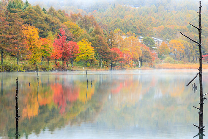

Alpine flower & Autumn leaves