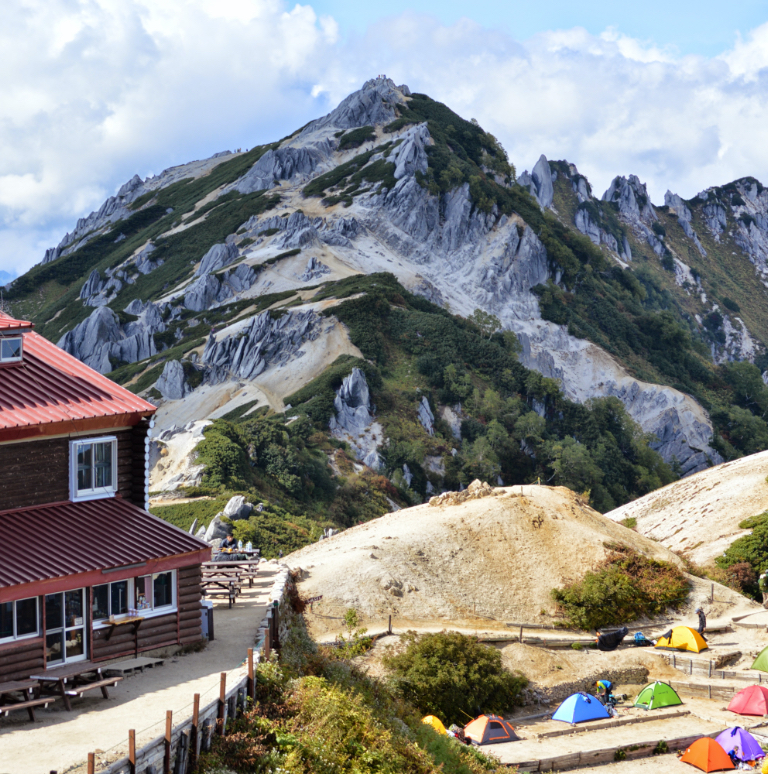
This mountain locates at the border line between the northwest of Yamanashi Prefecture and the southeast of Nagano prefecture. It is called the queen of the South Japan Alps from the gradual shape of the mountain and a wide variety of Alpine plant vegetation. From the summit, there are four main ridgelines that spread out and three depressions located among these ridgelines. The four ridgelines are Umanose o’ne in the north, Senshio o’ne in the south from Mt. Senjo-gatake, Syo-senjo o’ne in the northeast, and Jizou o’ne in the west. The depressions are Yabusawa, Syo-senjo, and Dai-senjo. Despite its elevation over 3,000 m, it is popular as an entry level mountain among the South Japan Alps. If hiking only Mt. Senjo-gatake, most approach from Kitazawa pass. If you stay a night at Kitazawa pass, you can climb Mt. Senjo-gatake and Mt. Kaikoma-gatake. The camping site at Kitazawa pass becomes very busy during the summer season. Once the alpine plants in the area between the summit of Mt. Senjo-gatake and Umanose hut died out due to the deer habitation. At that time deer crossed the ridgelines at an elevation of 3,000 m. Although a variety of alpine plants can be enjoyed nowadays, it actually took more than 10 years to reconstruct the vegetation. Be careful not to enter preserved areas or step on alpine plants along the trail. Do not pick alpine plants.
Mt. Senjo-gatake: Elevation 3,032 m
From Kitazawa Touge pass, the trail is steep but there are no zones requiring the use of chains and ladders. Hiking on a snowy valley can be enjoyed in early summer season. There is a hut along the trail as well. It can be considered as the entry course of climbing mountains at an elevation of 3,000 m and higher, rather than hiking through the South Japan Alps. Mt. Senjo-gatake locates at the north edge of the South Japan Alps. Some hike from one mountain to another towards the south, starting from this mountain. Those hikers can be seen on Senshio o’ne in the summer season. Some hike to Mt. Kita-dake then ride a bus to Kitazawa Touge pass from Hiro-gawara. There are two mountain huts and a camping site at Kitazawa Toge pass.
Trailhead vicinity weather
Weekly weather forecast zone:Midwestern region of Yamanashi Prefecture
| DAY | WEATHER | LOWEST | HIGHEST |
|---|---|---|---|
| 7/14 | 23℃ | 31℃ | |
| 7/15 | 24℃ | 28℃ | |
| 7/16 | 24℃ | 30℃ | |
| 7/17 | 25℃ | 31℃ | |
| 7/18 | 24℃ | 35℃ | |
| 7/19 | 24℃ | 36℃ |
This is a publication of the calculated figures for weather predictions and is not the weather forecast. There are instances where there will be big differences in the values stated for the mountains, in accord with the topography as well as sunlight, etc. so please take care.
72 hours weather information:Southern Nagano Prefecture
| Date and time |
7/13 18:00 |
7/13 19:00 |
7/13 20:00 |
7/13 21:00 |
7/13 22:00 |
7/13 23:00 |
7/14 0:00 |
7/14 1:00 |
7/14 2:00 |
7/14 3:00 |
7/14 4:00 |
7/14 5:00 |
7/14 6:00 |
7/14 7:00 |
7/14 8:00 |
7/14 9:00 |
7/14 10:00 |
7/14 11:00 |
7/14 12:00 |
7/14 13:00 |
7/14 14:00 |
7/14 15:00 |
7/14 16:00 |
7/14 17:00 |
7/14 18:00 |
7/14 19:00 |
7/14 20:00 |
7/14 21:00 |
7/14 22:00 |
7/14 23:00 |
7/15 0:00 |
7/15 1:00 |
7/15 2:00 |
7/15 3:00 |
7/15 4:00 |
7/15 5:00 |
7/15 6:00 |
7/15 7:00 |
7/15 8:00 |
7/15 9:00 |
7/15 10:00 |
7/15 11:00 |
7/15 12:00 |
7/15 13:00 |
7/15 14:00 |
7/15 15:00 |
7/15 16:00 |
7/15 17:00 |
7/15 18:00 |
7/15 19:00 |
7/15 20:00 |
7/15 21:00 |
7/15 22:00 |
7/15 23:00 |
7/16 0:00 |
|---|---|---|---|---|---|---|---|---|---|---|---|---|---|---|---|---|---|---|---|---|---|---|---|---|---|---|---|---|---|---|---|---|---|---|---|---|---|---|---|---|---|---|---|---|---|---|---|---|---|---|---|---|---|---|---|
| Weather | |||||||||||||||||||||||||||||||||||||||||||||||||||||||
| Temperature | 19℃ | 18℃ | 17℃ | 16℃ | 15℃ | 14℃ | 14℃ | 14℃ | 14℃ | 15℃ | 15℃ | 15℃ | 15℃ | 15℃ | 16℃ | 17℃ | 18℃ | 18℃ | 18℃ | 19℃ | 20℃ | 19℃ | 19℃ | 18℃ | 17℃ | 17℃ | 16℃ | 16℃ | 16℃ | 16℃ | 17℃ | 17℃ | 16℃ | 16℃ | 16℃ | 16℃ | 15℃ | 16℃ | 16℃ | 16℃ | 16℃ | 16℃ | 17℃ | 16℃ | 17℃ | 17℃ | 18℃ | 17℃ | 17℃ | 17℃ | 15℃ | 15℃ | 14℃ | 14℃ | 14℃ |
| Precipitation | 0mm/h | 0mm/h | 0mm/h | 0mm/h | 0mm/h | 0mm/h | 0mm/h | 0mm/h | 0mm/h | 0mm/h | 0mm/h | 0mm/h | 0mm/h | 0mm/h | 0mm/h | ※ 16時間以降は表示されません | |||||||||||||||||||||||||||||||||||||||
| Wind direction |
south-southwest 1m/s |
0m/s |
0m/s |
south-southwest 1m/s |
south-southwest 1m/s |
south-southwest 1m/s |
south-southwest 2m/s |
south-southwest 2m/s |
south-southwest 2m/s |
south-southwest 2m/s |
south-southwest 2m/s |
south-southwest 3m/s |
south-southwest 2m/s |
south-southwest 2m/s |
south-southwest 2m/s |
south-southwest 2m/s |
south-southwest 2m/s |
south-southwest 2m/s |
south-southwest 2m/s |
south-southwest 1m/s |
south-southwest 1m/s |
south-southwest 1m/s |
south-southwest 1m/s |
south-southwest 2m/s |
south-southwest 2m/s |
south-southwest 2m/s |
south-southwest 1m/s |
south-southwest 1m/s |
south-southwest 1m/s |
south-southwest 1m/s |
south-southwest 2m/s |
south-southwest 1m/s |
south-southwest 2m/s |
south-southwest 2m/s |
south-southwest 1m/s |
south-southwest 2m/s |
south-southwest 1m/s |
south-southwest 1m/s |
south-southwest 1m/s |
south-southwest 1m/s |
south-southwest 1m/s |
south-southwest 1m/s |
south-southwest 1m/s |
south-southwest 2m/s |
south-southwest 1m/s |
south-southwest 1m/s |
south-southwest 1m/s |
south-southwest 1m/s |
south-southwest 1m/s |
south-southwest 1m/s |
south-southwest 1m/s |
south-southwest 2m/s |
south-southwest 2m/s |
south-southwest 2m/s |
south-southwest 3m/s |
※The weather information will be information on 5km square including the relevant point.
※天気予報マークは一次細分区域から表示しています