Hiking Route for Mt. Yatsuga-take Autumn Leaves Viewing
The core part of South Yatsuga-take in Autumn Sakura-daira ~ Natsuzawa pass ~ Mt. Iou-dake ~ Mt. Yoko-dake ~ Mt. Aka-dake ~ Mt. Yoko-dake ~ Mt. Iou-dake ~ Natsuzawa pass ~ Sakura-daira
A very attractive route with great views
●Hiking Data
Schedule: One day or One night and Two days
Walking hours: 9 hours 15 minutes
(Up: 5 hours 20 minutes Down: 3 hours and 55 minutes)
Walking distance: 16.2 km
Variance in elevation: 1,010 m
Sakura-daira
Elevation 1,890m
↓ 1 hour 40 minutes
Natsuzawa pass
Elevation 2,430m
↓ 1 hour
Mt. Iou-dake
Elevation 2,741m
↓ 1 hour 20 minutes
Mt. Yoko-dake
Elevation 2,829m
↓ 1 hour 20 minutes
Mt. Aka-dake
Elevation 2,899m
↓ 1 hour 10 minutes
Mt. Yoko-dake
Elevation 2,829m
↓ 1 hour
Mt. Iou-dake
Elevation 2,741m
↓ 40 minutes
Natsuzawa pass
Elevation 2,430m
↓ 1 hour 5 minutes
Sakura-daira
Elevation 1,890m
Route Guide
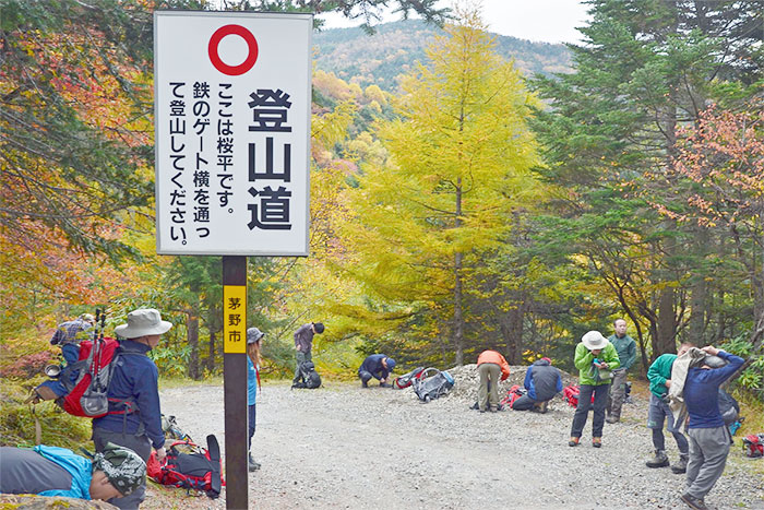
The busiest trail head with easy access in Mt. Yatsuga-take is Minoto trail head, which is a starting point for various routes. However, Sakura-daira is getting popular as well. It is located at 1,890 m in elevation, which is 400 m higher than Minoto trail head and that makes for a variance in elevation to Mt. Aka-dake two thirds of it from Minoto trailhead. This makes this trail easier hiking from a physical strength standpoint. That is the biggest reason for its growing popularity.
The difficulty of access to Sakura-daira is that there is no public transportation available but only taxis. It takes about 1 hour from Chino station of the JR Chuo-honsen and it costs 7,500 Yen. A jumbo taxi for 9 customers at max costs about 12,000 yen, therefore, it might be reasonable if you can bring a bigger party. If you drive yourself, it takes 30 minutes from Suwa IC of Chuo Expressway for a 21 km ride to Sakura-daira trailhead. The free parking lot may accommodate about 150 cars.
If you drive yourself, you may take a round trip to Sakura-daira. If you utilize public transportation, from Mt. Aka-dake, you may also descend on the South Yatsuga-take ridgeline route to Minoto trailhead, introduced earlier. Or you may take a round trip to Mt. Iou-dake, which takes about 4 hours and 25 minutes over an 8.8 km length instead of going to Mt. Aka-dake. Since you may avoid the rocky zones of Mt. Yoko-dake and Mt. Aka-dake, the route’s technical level becomes a C and the physical strength level becomes a 2.
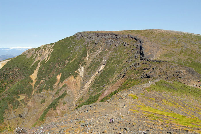
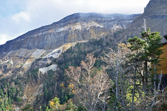
Park at Sakura-daira trail head and walk through the gate towards a logging road. Ascend the trail from Natsuzawa-kosen. Walk through an evergreen coniferous tree forest. Oren-koya Mountain hut will be reached when the forest opens up. From there, ascend a dried stream-like trail to Natsuzawa pass. An exploded crater wall of Mt. Iou-dake on the main ridgeline between the North and South Yatsuga-take can be viewed. Hute Natsuzawa and Yamabiko-sou Mountain hut stand across the ridgeline.
After a hill climb from Natsuzawa pass, the trail passes a tree line and it becomes a steep graveled slope in a zigzag pattern, going through Pinus Pumila.
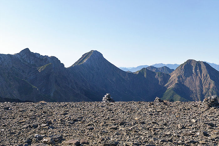
Mt. Tateshina-yama can be looked back on. Once you reach the wide and flat summit of Mt. Iou-dake, the view of Mt. Yoko-dake, to Mt. Aka-dake and Mt. Amida-dake spreads out in front of you and it is very impressive. The North Japan Alps can also be seen.
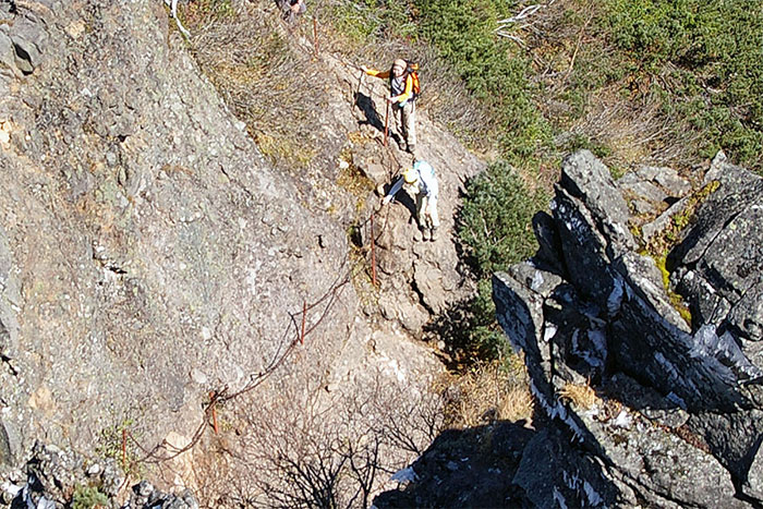
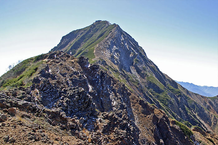
Descend on a gradual slope towards Mt. Aka-dake. O-darumi, where the Iou-dake-sanso Mountain hut stands, will be reached. In summer alpine plants such as Dicentra can be enjoyed around here. Ascend again towards Mt. Yoko-dake on a gradual slope at the beginning. The trail becomes rocky and passes some spots with chains and ladders in use, which makes a ridgeline walking thrilling. Mt. Yoko-dake/Okuno-in will be reached. After Okuno-in, there are more zones requiring the use of chains and after passing rocky areas, Jizono-kashira is reached. From Aka-dake Tenbou-sou Mountain hut, the trail becomes an uphill towards Mt. Aka-dake. It is not as steep as the trail to Mt. Yoko-dake, however, the trail includes rocky areas so make sure that you stay focused on your path.
The north peak of Mt. Aka-dake, where Akadake-Chojo-sanso Mountain hut stands, will be reached. The south peak of Mt. Aka-dake, the highest peak of Mt. Yatsuga-take stands, just ahead of the north peak and the triangulation spot is set there, at an elevation of 2,899.4 m. A 360-degrees panoramic view extends, and Mt. Fuji and the South Japan Alps can be seen very well. After enjoying the view, start descending. Extra caution must be exercised for a descending route of Mt. Aka-dake if you are making a round trip, and the rocky area of Mt. Yoko-dake if you are descending to Minoto trail head. Be careful not to slip or drop rocks.
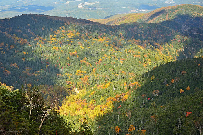
The best season for Autumn leaves of Alpine plants above the mountains and shrubs such as Actous Alpina is late September to early October. The best season for Betula Ermani and Rowan trees mixing with coniferous trees at the middle of mountains is early to late October. The best season for decidious broad-leaved trees and larches nearby trailhead is middle to late Ocobter. During Autumn Leaves season, when weather turns badly, it might snow or icy rain. You must prepare appropriate gears. It is also recommended to hike with experts if you re beginners. Safety caution must be exercised.