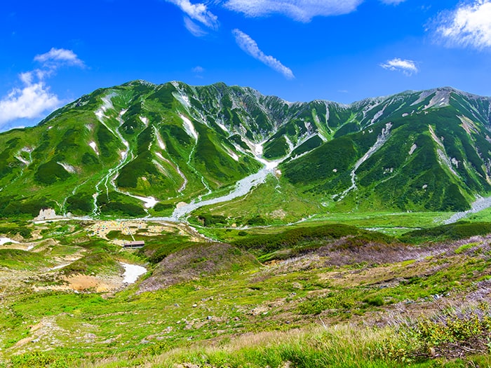
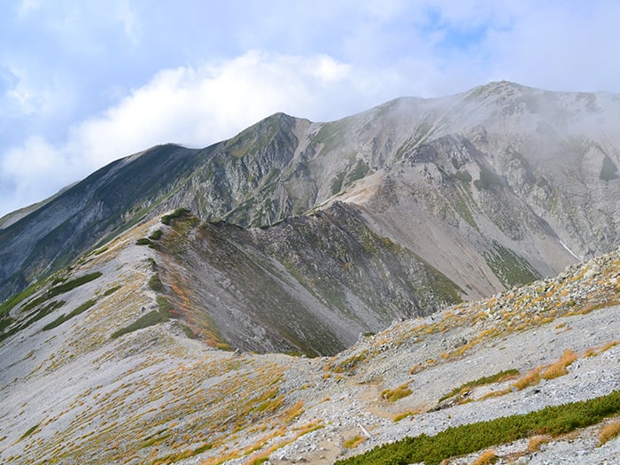
Tateyama Mountains is representative of the mountains in Chubu-Sangaku National Park and is located in the northern part of the Northern Japan Alps. Interestingly, a mountain named Mt. Tate-yama does not exist. In general, three mountains, Mt. O’yama (3,003M), Mt. O-nanji-yama (3,015M), and Mt. Fujino-oritate, are called Tateyama mountains. The main peak is Mt. O’yama and the highest peak is Mt. O-nanji-yama.
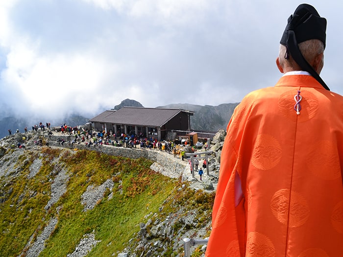
Tateyama Mountains, known from the past as a place for mountain worship, is also known as one of Japan’s three holy mountains with Mt. Fuji-yama, Mt. Haku-san.
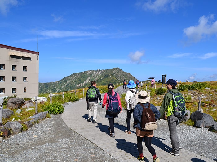
O’yama Shrine stands at the peak of Mt. O’yama and in summer hiking season, a prayer service is held by a Shinto priest.
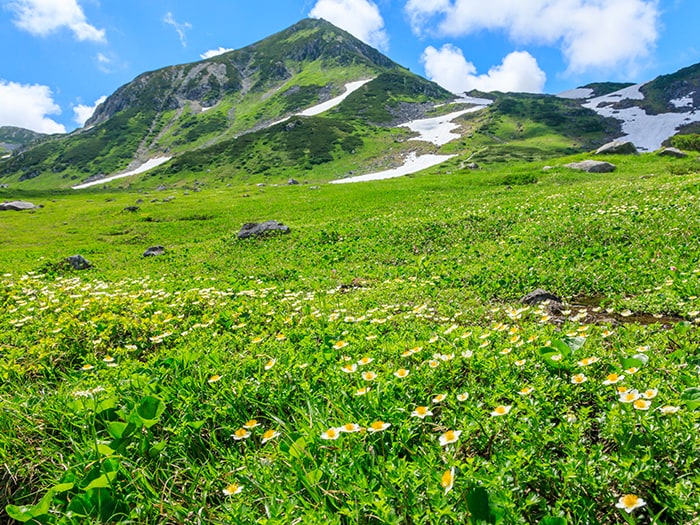
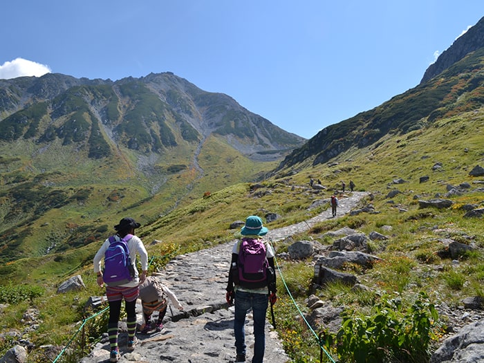
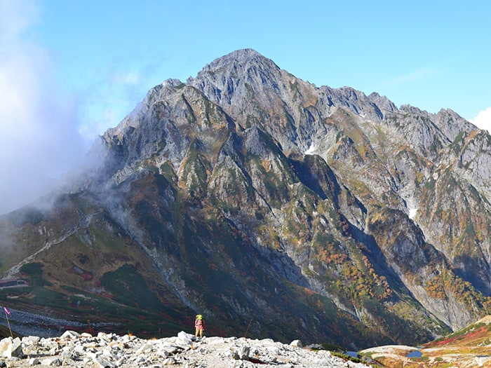
Tateyama Mountains keep people away for more than half a year, even then, many hikers visit the mountain to enjoy the wide variety of alpine plants in season. There is also a good chance that one will encounter ptarmigan in this area.
Tateyama Mountains : Elevation 3,015m (Highest Peak Mt. O-nanji-yama)
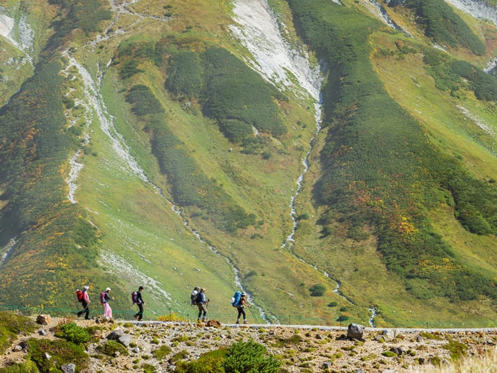
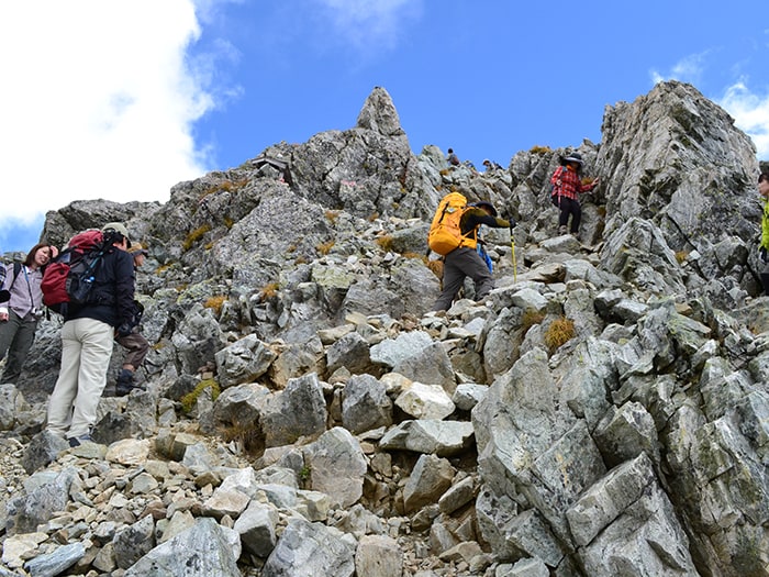
The typical route to Mt. O’yama and Mt. O-naji-yama starts from Murodo, passing by Ichi-nokoshi to the summits. Most hikers, however, take the trail back when they reach Mt. O’yama and do not continue to hike to Mt. O-naji-yama. They visit the mountain out of religious faith and do not seem interested in the highest peak of Tateyama mountains. A trail from Mt. O’yama to Mt. O-naji-yama is a graveled ridgeline but does not include a hazardous zone. The hike on this path gives you a rare experience of a 3,000m altitude ridge walk so it is highly recommended.
From Murodo, there is a trail which passes Mt. Ryuo-dake and reaches Mt. O’yama by Ichi-nokoshi or another trail that climbs up from Raicho-sawa to Raicho-saka, then reaches a ridgeline by Bessan-nokkoshi to Mt. O’yama.
For the beginners, a round trip from Murodo ~ Ichi-nokoshi ~ Mt. O’yama ~ Mt. O-naji is recommended.
Also, many hikers enjoy the route from Mt. O-naji-yama ~ Fujino-oritate ~ Bessan ~Bessan-nokkoshi ~ Raicho-sawa ~ Murodo.
Trailhead vicinity weather
Weekly weather forecast zone:Toyama Prefecture Eastern Region
| DAY | WEATHER | LOWEST | HIGHEST |
|---|---|---|---|
| 7/16 | 26℃ | 35℃ | |
| 7/17 | 26℃ | 34℃ | |
| 7/18 | 26℃ | 36℃ | |
| 7/19 | 24℃ | 35℃ | |
| 7/20 | 25℃ | 35℃ | |
| 7/21 | 25℃ | 35℃ |
This is a publication of the calculated figures for weather predictions and is not the weather forecast. There are instances where there will be big differences in the values stated for the mountains, in accord with the topography as well as sunlight, etc. so please take care.
72 hours weather information:Ashikuraji Tateyama Murodou-daira, Tateyama-cho, Nakashinagawa-gun, Toyama
| Date and time |
7/15 12:00 |
7/15 13:00 |
7/15 14:00 |
7/15 15:00 |
7/15 16:00 |
7/15 17:00 |
7/15 18:00 |
7/15 19:00 |
7/15 20:00 |
7/15 21:00 |
7/15 22:00 |
7/15 23:00 |
7/16 0:00 |
7/16 1:00 |
7/16 2:00 |
7/16 3:00 |
7/16 4:00 |
7/16 5:00 |
7/16 6:00 |
7/16 7:00 |
7/16 8:00 |
7/16 9:00 |
7/16 10:00 |
7/16 11:00 |
7/16 12:00 |
7/16 13:00 |
7/16 14:00 |
7/16 15:00 |
7/16 16:00 |
7/16 17:00 |
7/16 18:00 |
7/16 19:00 |
7/16 20:00 |
7/16 21:00 |
7/16 22:00 |
7/16 23:00 |
7/17 0:00 |
7/17 1:00 |
7/17 2:00 |
7/17 3:00 |
7/17 4:00 |
7/17 5:00 |
7/17 6:00 |
7/17 7:00 |
7/17 8:00 |
7/17 9:00 |
7/17 10:00 |
7/17 11:00 |
7/17 12:00 |
7/17 13:00 |
7/17 14:00 |
7/17 15:00 |
7/17 16:00 |
7/17 17:00 |
7/17 18:00 |
7/17 19:00 |
7/17 20:00 |
7/17 21:00 |
7/17 22:00 |
7/17 23:00 |
7/18 0:00 |
|---|---|---|---|---|---|---|---|---|---|---|---|---|---|---|---|---|---|---|---|---|---|---|---|---|---|---|---|---|---|---|---|---|---|---|---|---|---|---|---|---|---|---|---|---|---|---|---|---|---|---|---|---|---|---|---|---|---|---|---|---|---|
| Weather | |||||||||||||||||||||||||||||||||||||||||||||||||||||||||||||
| Temperature | 20℃ | 22℃ | 22℃ | 22℃ | 21℃ | 20℃ | 20℃ | 19℃ | 17℃ | 16℃ | 15℃ | 15℃ | 15℃ | 15℃ | 15℃ | 15℃ | 15℃ | 15℃ | 15℃ | 16℃ | 16℃ | 18℃ | 18℃ | 19℃ | 19℃ | 20℃ | 20℃ | 19℃ | 19℃ | 19℃ | 19℃ | 18℃ | 16℃ | 16℃ | 16℃ | 16℃ | 17℃ | 17℃ | 17℃ | 16℃ | 16℃ | 16℃ | 16℃ | 16℃ | 16℃ | 16℃ | 16℃ | 16℃ | 16℃ | 16℃ | 16℃ | 16℃ | 16℃ | 16℃ | 16℃ | 15℃ | 15℃ | 15℃ | 15℃ | 15℃ | 14℃ |
| Precipitation | 0.4mm/h | 1mm/h | 0.4mm/h | 0mm/h | 0mm/h | 0mm/h | 0mm/h | 0mm/h | 0mm/h | 0mm/h | 0mm/h | 0mm/h | 0mm/h | 0mm/h | 0mm/h | ※ 16時間以降は表示されません | |||||||||||||||||||||||||||||||||||||||||||||
| Wind direction |
south-southeast 2m/s |
south-southeast 1m/s |
south-southeast 1m/s |
south-southeast 1m/s |
south-southeast 1m/s |
south-southeast 1m/s |
south-southeast 1m/s |
south-southeast 1m/s |
south-southeast 1m/s |
south-southeast 1m/s |
south-southeast 2m/s |
south-southeast 2m/s |
south-southeast 2m/s |
south-southeast 3m/s |
south-southeast 3m/s |
south-southeast 3m/s |
south-southeast 2m/s |
south-southeast 2m/s |
south-southeast 2m/s |
south-southeast 2m/s |
south-southeast 2m/s |
south-southeast 2m/s |
south-southeast 2m/s |
south-southeast 2m/s |
south-southeast 2m/s |
south-southeast 1m/s |
south-southeast 1m/s |
south-southeast 1m/s |
south-southeast 1m/s |
south-southeast 1m/s |
south-southeast 1m/s |
south-southeast 2m/s |
south-southeast 2m/s |
south-southeast 2m/s |
south-southeast 2m/s |
south-southeast 2m/s |
south-southeast 2m/s |
south-southeast 2m/s |
south-southeast 2m/s |
south-southeast 2m/s |
south-southeast 2m/s |
south-southeast 2m/s |
south-southeast 2m/s |
south-southeast 3m/s |
south-southeast 2m/s |
south-southeast 2m/s |
south-southeast 2m/s |
south-southeast 3m/s |
south-southeast 3m/s |
south-southeast 3m/s |
south-southeast 3m/s |
south-southeast 3m/s |
south-southeast 3m/s |
south-southeast 3m/s |
south-southeast 3m/s |
south-southeast 3m/s |
south-southeast 3m/s |
south-southeast 3m/s |
south-southeast 2m/s |
south-southeast 2m/s |
south-southeast 2m/s |
※The weather information will be information on 5km square including the relevant point.
※天気予報マークは一次細分区域から表示しています
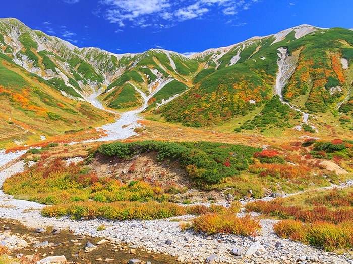
View of Tateyama Mountains


Route Information
A-Basic course sorted by trailheads
From Murodo
-
Ichi-nokoshi Route
① Murodo ~ Ichi-nokoshi ~ Mt. O'yama ~ Mt. O-naji-yama ~ Mt. O'yama ~ Ichi-nokoshi ~ Murodo (Difficulty level: ⛰️) -
Murodo loop Route
②Murodo ~ Ichi-nokoshi ~ Mt. O'yama ~ Mt. O-naji-yama ~ Mt. Fujino-Oritate ~ Bessan~Bessan-nokkoshi ~ Raicho-sawa ~ Mikuriga ike Pond-hot spring ~ Murodo (Difficulty level: ⛰️⛰️)
