Mt. Nishi-hotaka-dake is said to have been named by “Masao Udono,” who first traversed the Yari-hotaka range more than 100 years ago, at the end of the Meiji period. He must have been a true explorer of this era, as he also traversed the Mt. Nishi-hotaka-dake – Mt. Oku-hotaka-dake section where the gendarmes are located.
Located in the southwestern part of the hotaka mountain range, it is a part of the hotaka mountain range along with Mt. Mae-hotaka^dake and Mt. Kita-hotaka-dake, but it is the only summit in the mountain range below 3,000 meters. The ropeway makes it relatively easy to approach Nishiho Sanso mountain hut, the base of the mountain, and it would certainly be a good place for beginners to visit Nishiho Sanso mountain hut as their first mountain lodge or to walk to the altitude point on this mountain first as an introduction to the Northern Alps.
However, it is a different world beyond the midway elevation point. This is not a mountain for beginners or novice climbers.
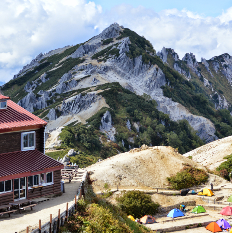
Mt. Nishi-hotaka-dake Peak is the first peak, and the Nishiho elevation point is the 11th peak. The jagged peaks, whether seen from Kamikochi or from the ropeway station, convey the power and severity of the mountain, which is not easily accessible.
The difficult part is downhill from this elevation point, and the route will be challenging, traversing and crossing peaks along the way and ascending and descending heavily for short distances.
Furthermore, Nishiho Sanso mountain hut is the only lodge in the North Alps that is open year-round, making it a good entry point for experiencing the North Alps during the harsh winter season. However, it is not easy to come here as you will have to walk through snow from the ropeway station. Please go out with an experienced person or a guide on top of winter equipment. Mt. Nishi-hotaka is also designated as one of the 100 most beautiful mountains in Japan for its flowers.
Mt. Nishi-hotaka-dake: Elevation 2,909 m
The most popular and easy-to-access route to Mt. Nishi-hotaka-dake is from the Shin Hotaka ropeway. From the ropeway summit station Nishi-hotaka Exit to Nishiho Sanso mountain hut, there is little elevation gain, and in summer, it takes about one and a half hours to reach the summit. However, the climb to Mt. Nishi-hotaka-dake begins in earnest from this point onward.
On the other hand, if you use Kamikochi as your base, there is a direct route up to Nishiho Sanso mountai nhut without detouring from Kamikochi to the ropeway. Unlike the walk from the ropeway, this is a solid climbing route.There are also many who take the ridge walking approach from Mt. Yake-dake.
Trailhead vicinity weather
Weekly weather forecast zone:Hida region, Gifu Prefecture
| DAY | WEATHER | LOWEST | HIGHEST |
|---|---|---|---|
| 3/25 | 10℃ | 17℃ | |
| 3/26 | 10℃ | 18℃ | |
| 3/27 | 10℃ | 19℃ | |
| 3/28 | 11℃ | 19℃ | |
| 3/29 | 9℃ | 20℃ | |
| 3/30 | 9℃ | 19℃ |
This is a publication of the calculated figures for weather predictions and is not the weather forecast. There are instances where there will be big differences in the values stated for the mountains, in accord with the topography as well as sunlight, etc. so please take care.
72 hours weather information:Ajimu, Matsumoto City, Nagano Prefecture Kamikochi Kappa Bridge
| Date and time |
3/24 17:00 |
3/24 18:00 |
3/24 19:00 |
3/24 20:00 |
3/24 21:00 |
3/24 22:00 |
3/24 23:00 |
3/25 0:00 |
3/25 1:00 |
3/25 2:00 |
3/25 3:00 |
3/25 4:00 |
3/25 5:00 |
3/25 6:00 |
3/25 7:00 |
3/25 8:00 |
3/25 9:00 |
3/25 10:00 |
3/25 11:00 |
3/25 12:00 |
3/25 13:00 |
3/25 14:00 |
3/25 15:00 |
3/25 16:00 |
3/25 17:00 |
3/25 18:00 |
3/25 19:00 |
3/25 20:00 |
3/25 21:00 |
3/25 22:00 |
3/25 23:00 |
3/26 0:00 |
3/26 1:00 |
3/26 2:00 |
3/26 3:00 |
3/26 4:00 |
3/26 5:00 |
3/26 6:00 |
3/26 7:00 |
3/26 8:00 |
3/26 9:00 |
3/26 10:00 |
3/26 11:00 |
3/26 12:00 |
3/26 13:00 |
3/26 14:00 |
3/26 15:00 |
3/26 16:00 |
3/26 17:00 |
3/26 18:00 |
3/26 19:00 |
3/26 20:00 |
3/26 21:00 |
3/26 22:00 |
3/26 23:00 |
3/27 0:00 |
|---|---|---|---|---|---|---|---|---|---|---|---|---|---|---|---|---|---|---|---|---|---|---|---|---|---|---|---|---|---|---|---|---|---|---|---|---|---|---|---|---|---|---|---|---|---|---|---|---|---|---|---|---|---|---|---|---|
| Weather | ||||||||||||||||||||||||||||||||||||||||||||||||||||||||
| Temperature | 2℃ | 1℃ | 0℃ | -1℃ | -1℃ | -2℃ | -3℃ | -4℃ | -6℃ | -7℃ | -7℃ | -6℃ | -5℃ | -5℃ | -6℃ | -5℃ | -3℃ | -1℃ | 1℃ | 2℃ | 3℃ | 3℃ | 3℃ | 3℃ | 2℃ | 1℃ | 0℃ | -1℃ | -1℃ | -1℃ | -1℃ | -1℃ | -1℃ | -1℃ | -1℃ | -1℃ | -1℃ | -2℃ | -2℃ | -1℃ | 0℃ | 0℃ | 1℃ | 1℃ | 1℃ | 1℃ | 1℃ | 1℃ | 1℃ | 1℃ | 0℃ | -2℃ | -2℃ | -2℃ | -2℃ | -2℃ |
| Precipitation | 0mm/h | 0mm/h | 0mm/h | 0mm/h | 0mm/h | 0mm/h | 0mm/h | 0mm/h | 0mm/h | 0mm/h | 0mm/h | 0mm/h | 0mm/h | 0mm/h | 0mm/h | ※ 16時間以降は表示されません | ||||||||||||||||||||||||||||||||||||||||
| Wind direction |
north 1m/s |
north 1m/s |
north 1m/s |
0m/s |
0m/s |
0m/s |
north 1m/s |
north 2m/s |
north 2m/s |
north 2m/s |
north 2m/s |
north 2m/s |
north 2m/s |
north 1m/s |
north 2m/s |
north 2m/s |
north 1m/s |
north 1m/s |
north 1m/s |
north 2m/s |
north 2m/s |
north 2m/s |
north 2m/s |
north 1m/s |
north 1m/s |
north 1m/s |
0m/s |
north 1m/s |
north 1m/s |
north 1m/s |
north 1m/s |
north 1m/s |
north 1m/s |
north 1m/s |
north 1m/s |
north 1m/s |
north 1m/s |
north 1m/s |
north 1m/s |
north 1m/s |
0m/s |
north 1m/s |
north 1m/s |
north 1m/s |
north 1m/s |
north 2m/s |
north 1m/s |
north 1m/s |
north 1m/s |
north 1m/s |
north 1m/s |
north 1m/s |
north 1m/s |
north 1m/s |
north 1m/s |
north 1m/s |
※The weather information will be information on 5km square including the relevant point.
※天気予報マークは一次細分区域から表示しています