
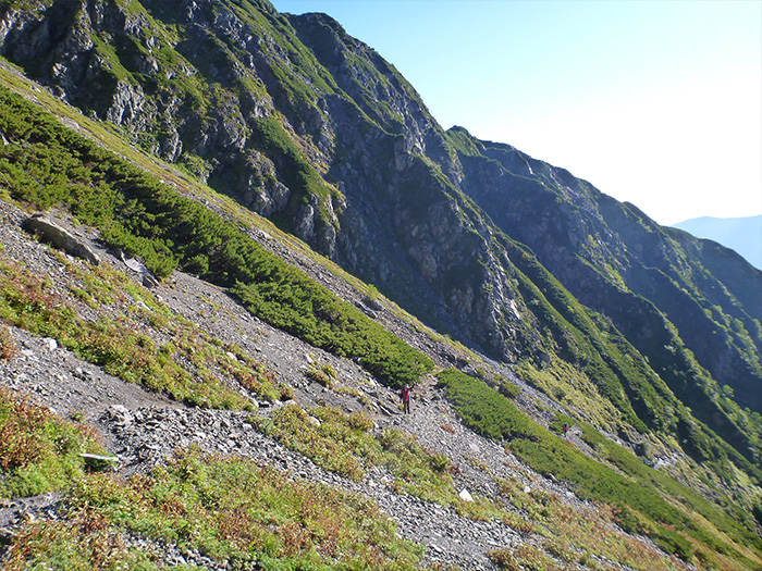
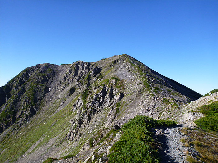
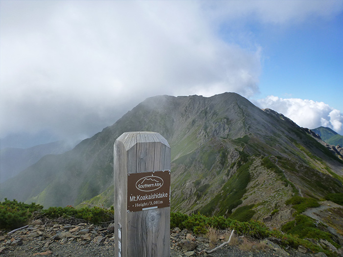
Mt. Akaishi-dake belongs to The Akaishi Mountain Range, which hold mountains of 3,000 m or more altitude and starts from Mt. Mitsumine-dake, separating from Mt. Aino-dake. It is also referred to as the leader of the Southern Japan Alps. The elevation is 3,210 m. The mountain sitting next to it, Mt. Ko-Akaishi-dake is 3,081 m and is also a high peak. These mountains rank among the fourth highest in the Southern Japan Alps, after Mt. Kita-dake, Mt. Aino-dake, and Mt. Higashi-dake (Mt.Warusawa-dake). First the triangulation point is set at the summit. There are some circles that spread out on the eastern slope of the ridgeline. This is a remaining mark of an old glacier at the most southern point in Japan. On the southwestern slope, Goro, a geographical feature of a rock glacier, can be seen. A trail from Mt. Ko-Akaishi-dake to Mt. Akaishi-dake is covered by Pinus Pumila and a flower field spreads out. You may encounter some ptarmigans as well. Akaishi-rindo, an endemic species, is categorized in the red list, an endangered species of the IB class (EN), by the ministry of the Environment. The name of the mountain comes after a reddish radiolarite, which makes up a part of the mountain.
Mt. Akaishi-dake: Elevation 3,210m
This mountain is climbed often with The Arakawa Three mountains, however, a route starting from Sawara-jima to Mt. Akaishi-dake via Mt. Ko-Akaishi dake then proceeding to Mt. Hijiri-dake, is popular as well. In that case, it is time efficient to descend from Hijiri-daira-koya Mountain hut to Hijiri-sawa trailhead and walk to Sawara-jima. However, it requires more than three nights to complete the route. If time is limited, a round trip from Sawara-jima to Mt. Akaishi-dake is recommended. On this route, you may stay at Sawara-jima the night before and stay another night in the mountain. If you are aiming to climb Mt. Akaishi-dake only, then this course is recommended. Most hikers choose this route. Also, another route from Mt. Hijiri-dake to Mt. Akaishi-dake is introduced as the Southern Japan Alps ⑨ Mt. Hijiri-dake. Please refer to the route if interested.
Trailhead vicinity weather
Weekly weather forecast zone:Chubu region, Shizuoka prefecture
| DAY | WEATHER | LOWEST | HIGHEST |
|---|---|---|---|
| 7/7 | 26℃ | 33℃ | |
| 7/8 | 27℃ | 32℃ | |
| 7/9 | 26℃ | 32℃ | |
| 7/10 | 26℃ | 32℃ | |
| 7/11 | 26℃ | 32℃ | |
| 7/12 | 26℃ | 32℃ |
This is a publication of the calculated figures for weather predictions and is not the weather forecast. There are instances where there will be big differences in the values stated for the mountains, in accord with the topography as well as sunlight, etc. so please take care.
72 hours weather information:Sawarajima Lodge, 1301-3 Tashiro, Aoi Ku, Shizuoka City, Shizuoka Prefecture
| Date and time |
7/6 7:00 |
7/6 8:00 |
7/6 9:00 |
7/6 10:00 |
7/6 11:00 |
7/6 12:00 |
7/6 13:00 |
7/6 14:00 |
7/6 15:00 |
7/6 16:00 |
7/6 17:00 |
7/6 18:00 |
7/6 19:00 |
7/6 20:00 |
7/6 21:00 |
7/6 22:00 |
7/6 23:00 |
7/7 0:00 |
7/7 1:00 |
7/7 2:00 |
7/7 3:00 |
7/7 4:00 |
7/7 5:00 |
7/7 6:00 |
7/7 7:00 |
7/7 8:00 |
7/7 9:00 |
7/7 10:00 |
7/7 11:00 |
7/7 12:00 |
7/7 13:00 |
7/7 14:00 |
7/7 15:00 |
7/7 16:00 |
7/7 17:00 |
7/7 18:00 |
7/7 19:00 |
7/7 20:00 |
7/7 21:00 |
7/7 22:00 |
7/7 23:00 |
7/8 0:00 |
7/8 1:00 |
7/8 2:00 |
7/8 3:00 |
7/8 4:00 |
7/8 5:00 |
7/8 6:00 |
7/8 7:00 |
7/8 8:00 |
7/8 9:00 |
7/8 10:00 |
7/8 11:00 |
7/8 12:00 |
7/8 13:00 |
7/8 14:00 |
7/8 15:00 |
7/8 16:00 |
7/8 17:00 |
7/8 18:00 |
7/8 19:00 |
7/8 20:00 |
7/8 21:00 |
7/8 22:00 |
7/8 23:00 |
7/9 0:00 |
|---|---|---|---|---|---|---|---|---|---|---|---|---|---|---|---|---|---|---|---|---|---|---|---|---|---|---|---|---|---|---|---|---|---|---|---|---|---|---|---|---|---|---|---|---|---|---|---|---|---|---|---|---|---|---|---|---|---|---|---|---|---|---|---|---|---|---|
| Weather | ||||||||||||||||||||||||||||||||||||||||||||||||||||||||||||||||||
| Temperature | 16℃ | 18℃ | 19℃ | 20℃ | 21℃ | 22℃ | 22℃ | 21℃ | 21℃ | 21℃ | 20℃ | 19℃ | 19℃ | 18℃ | 17℃ | 17℃ | 17℃ | 16℃ | 16℃ | 16℃ | 16℃ | 16℃ | 16℃ | 16℃ | 17℃ | 18℃ | 18℃ | 19℃ | 20℃ | 19℃ | 19℃ | 19℃ | 20℃ | 19℃ | 19℃ | 19℃ | 19℃ | 18℃ | 18℃ | 17℃ | 17℃ | 17℃ | 17℃ | 17℃ | 16℃ | 17℃ | 16℃ | 16℃ | 17℃ | 18℃ | 18℃ | 19℃ | 20℃ | 19℃ | 19℃ | 19℃ | 18℃ | 18℃ | 18℃ | 18℃ | 18℃ | 17℃ | 17℃ | 17℃ | 16℃ | 16℃ |
| Precipitation | 0mm/h | 0mm/h | 0mm/h | 0mm/h | 0mm/h | 0mm/h | 0mm/h | 0mm/h | 0mm/h | 0mm/h | 0mm/h | 0mm/h | 1mm/h | 2mm/h | 0mm/h | ※ 16時間以降は表示されません | ||||||||||||||||||||||||||||||||||||||||||||||||||
| Wind direction |
northwest 2m/s |
northwest 2m/s |
northwest 2m/s |
northwest 1m/s |
northwest 1m/s |
northwest 1m/s |
0m/s |
0m/s |
0m/s |
0m/s |
northwest 1m/s |
northwest 1m/s |
0m/s |
northwest 1m/s |
northwest 1m/s |
northwest 1m/s |
northwest 1m/s |
northwest 1m/s |
northwest 1m/s |
northwest 1m/s |
northwest 1m/s |
northwest 1m/s |
northwest 1m/s |
northwest 1m/s |
northwest 1m/s |
0m/s |
northwest 1m/s |
northwest 1m/s |
northwest 1m/s |
northwest 1m/s |
northwest 1m/s |
northwest 1m/s |
0m/s |
0m/s |
northwest 1m/s |
northwest 1m/s |
northwest 1m/s |
northwest 1m/s |
northwest 1m/s |
northwest 1m/s |
northwest 1m/s |
northwest 1m/s |
northwest 1m/s |
northwest 1m/s |
northwest 1m/s |
northwest 1m/s |
northwest 1m/s |
northwest 1m/s |
northwest 1m/s |
northwest 1m/s |
northwest 1m/s |
northwest 1m/s |
northwest 1m/s |
northwest 2m/s |
northwest 2m/s |
northwest 2m/s |
northwest 2m/s |
northwest 2m/s |
northwest 1m/s |
northwest 1m/s |
northwest 1m/s |
northwest 1m/s |
northwest 1m/s |
northwest 1m/s |
northwest 1m/s |
northwest 1m/s |
※The weather information will be information on 5km square including the relevant point.
※天気予報マークは一次細分区域から表示しています
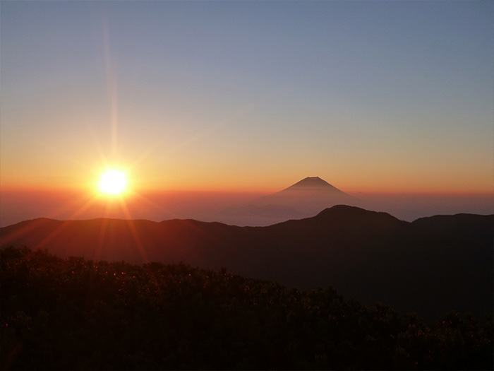
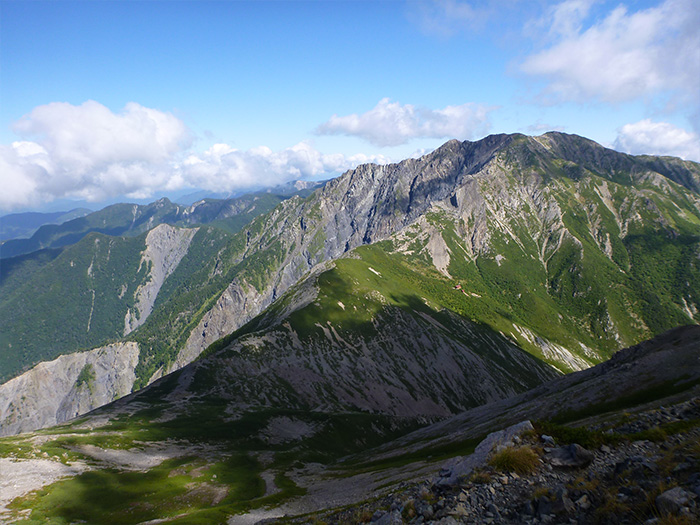
View of Mt. Akaishi-dake


Route Information
A-Basic course sorted by trailheads
From Sawara-jima
-
Akaishi o'ne Route
①Sawara-jima ~ Akaishi-koya Mountain hut ~ Fujimi-daira ~ Sawara-jima descending point ~ Mt. Akaishi-dake ~ Akaishi-koya Mountain hut ~ Sawara-jima (Difficulty level: ⛰️⛰️⛰️⛰️) -
Arakawa-dake Roundabout Route
②Sawara-jima ~ Senmai-koya Mountain hut ~ Mt. Senmai-dake ~ Mt. Higashi-dake (Mt. Warusawa- dake ) ~ Mt. Naka-dake ~ Mt. Mae-dake ~ Arakawa-koya Mountain hut ~ Mt. Akaishi-dake ~ Sawara-jima(Difficulty level: ⛰️⛰️⛰️⛰️)
